IMAGES TAKEN NEAR TO
Ampleforth Way, DARLINGTON, DL3 9SG
Introduction
This page details the photographs taken nearby to Ampleforth Way, DL3 9SG by members of the Geograph project.
The Geograph project started in 2005 with the aim of publishing, organising and preserving representative images for every square kilometre of Great Britain, Ireland and the Isle of Man.

There are currently over 7.5m images from over14,400 individuals and you can help contribute to the project by visiting https://www.geograph.org.uk
Image Map
Images are licensed for reuse under creativecommons.org/licenses/by-sa/2.0
Notes
- Clicking on the map will re-center to the selected point.
- The higher the marker number, the further away the image location is from the centre of the postcode.
Image Listing (11 Images Found)
Images are licensed for reuse under creativecommons.org/licenses/by-sa/2.0
Image
Details
Distance
2
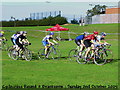
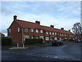
Branksome School : Cyclocross
The event will be held again this year.
Image: © Hugh Mortimer
Taken: 2 Oct 2005
0.15 miles
3
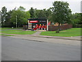
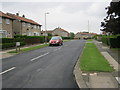
Convenience Store in Whitby Way Darlington
Image: © Peter Robinson
Taken: 23 Jun 2011
0.15 miles
4

Play area
In the Cocker Beck area near Branksome in the west of Darlington.
Image: © Peter Robinson
Taken: 18 Jun 2009
0.19 miles
5

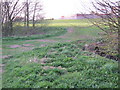
Cocker Beck Local Nature Reserve
Recently designated as a LNR and situated on the western side of Darlington
Image: © Peter Robinson
Taken: 18 Jun 2009
0.20 miles
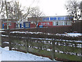
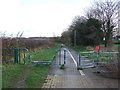
7
Farmers bridge over Cocker Beck Darlington
Image: © Peter Robinson
Taken: 9 Apr 2011
0.21 miles
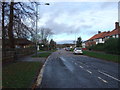
10
Cycle path on disused railway
Looking east from Newton Lane.
Image: © JThomas
Taken: 6 Dec 2015
0.23 miles