IMAGES TAKEN NEAR TO
Worsley Park, DARLINGTON, DL3 8SF
Introduction
This page details the photographs taken nearby to Worsley Park, DL3 8SF by members of the Geograph project.
The Geograph project started in 2005 with the aim of publishing, organising and preserving representative images for every square kilometre of Great Britain, Ireland and the Isle of Man.

There are currently over 7.5m images from over14,400 individuals and you can help contribute to the project by visiting https://www.geograph.org.uk
Image Map
Images are licensed for reuse under creativecommons.org/licenses/by-sa/2.0
Notes
- Clicking on the map will re-center to the selected point.
- The higher the marker number, the further away the image location is from the centre of the postcode.
Image Listing (5 Images Found)
Images are licensed for reuse under creativecommons.org/licenses/by-sa/2.0
Image
Details
Distance
1
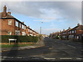
Swaledale Avenue Darlington
In the west of the town
Image: © Peter Robinson
Taken: 20 Nov 2009
0.13 miles
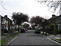
3
Nunnery Close Darlington
In the west of the town
Image: © Peter Robinson
Taken: 20 Nov 2009
0.23 miles
4
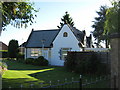
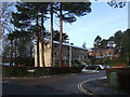
Wilton Lodge Darlington
Former gatehouse built in 1868 for the nearby Wilton Hall
Image: © Peter Robinson
Taken: 30 May 2009
0.24 miles