IMAGES TAKEN NEAR TO
Hadrian Court, DARLINGTON, DL3 8RE
Introduction
This page details the photographs taken nearby to Hadrian Court, DL3 8RE by members of the Geograph project.
The Geograph project started in 2005 with the aim of publishing, organising and preserving representative images for every square kilometre of Great Britain, Ireland and the Isle of Man.

There are currently over 7.5m images from over14,400 individuals and you can help contribute to the project by visiting https://www.geograph.org.uk
Image Map
Images are licensed for reuse under creativecommons.org/licenses/by-sa/2.0
Notes
- Clicking on the map will re-center to the selected point.
- The higher the marker number, the further away the image location is from the centre of the postcode.
Image Listing (24 Images Found)
Images are licensed for reuse under creativecommons.org/licenses/by-sa/2.0
Image
Details
Distance
1
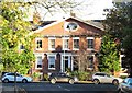
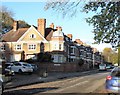
Grange Road elegance
Victorian terrace on Grange Road with a hint of classical style.
Image: © Gordon Hatton
Taken: 4 Nov 2017
0.09 miles
2
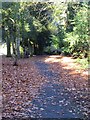
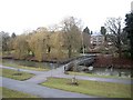
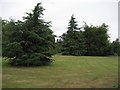
Green Oasis off Grange Road
A narrow strip of wooded parkland creates a green oasis on the west side of Grange Road.
Image: © Gordon Hatton
Taken: 4 Nov 2017
0.16 miles
3
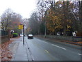
Grange Road (A167), Darlington
Heading south. Entrance to Polam Hall School on the left.
Image: © JThomas
Taken: 17 Nov 2012
0.19 miles
4
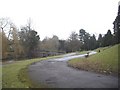
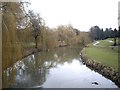
Approach to the South Park footbridge
Upstream the River Skerne.
Image: © Stanley Howe
Taken: 6 Mar 2010
0.20 miles
5
Footbridge over the River Skerne
South Park, Darlington. This bridge was built in 1960 to replace a 1939 wooden structure. A rockery laid out in 1933 lies between the bridge and the buildings on Grange Road (A161) in the rear.
Image: © Stanley Howe
Taken: 6 Mar 2010
0.20 miles
6
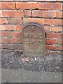
Old Milepost by Blackwell Lane, Darlington
Cast iron post by the B6280, in parish of Darlington (Darlington District), Blackwell Lane, opposite No. 78 against wall, on South side of road. Darlington GPO iron post erected by General Post Office in the 19th century, probably to assist with telegram delivery.
Inscription reads:-
1
MILE
G.P.O
Milestone Society National ID: DU_DAGPOb.
Image: © Milestone Society
Taken: 15 Mar 2017
0.20 miles
7
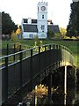
South Park scene
A footbridge over the River Skerne leads towards the white painted clock tower in South Park.
Image: © Gordon Hatton
Taken: 4 Nov 2017
0.20 miles
8
Upstream River Skerne
Into South Park, from Geneva Road bridge.
Image: © Stanley Howe
Taken: 6 Mar 2010
0.21 miles
9
Park to the West of the River Skerne
South Park is mostly to the east of the river - this little section is squeezed between the river and Grange Road on the west side.
Image: © Chris Heaton
Taken: 6 Jul 2010
0.21 miles
10
Terraced property on Southend Avenue
These large terraced properties on the south western fringe of the town centre mark the beginnings of the leafy suburbs on this side of the town. They are not shown on the 1899 map, but are on that of 1914. Southend Avenue appears to have been named after a villa that once stood behind these houses, and not after a brash resort in Essex.
Image: © Gordon Hatton
Taken: 4 Nov 2017
0.22 miles