IMAGES TAKEN NEAR TO
St. Hild Close, DARLINGTON, DL3 8LD
Introduction
This page details the photographs taken nearby to St. Hild Close, DL3 8LD by members of the Geograph project.
The Geograph project started in 2005 with the aim of publishing, organising and preserving representative images for every square kilometre of Great Britain, Ireland and the Isle of Man.

There are currently over 7.5m images from over14,400 individuals and you can help contribute to the project by visiting https://www.geograph.org.uk
Image Map
Images are licensed for reuse under creativecommons.org/licenses/by-sa/2.0
Notes
- Clicking on the map will re-center to the selected point.
- The higher the marker number, the further away the image location is from the centre of the postcode.
Image Listing (6 Images Found)
Images are licensed for reuse under creativecommons.org/licenses/by-sa/2.0
Image
Details
Distance
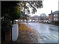
1
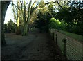
Cemetery Lane leading to Carmel Road North
Image: © Peter Robinson
Taken: 23 Dec 2012
0.11 miles
2
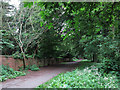
Lane adjacent to West Cemetery
The West Cemetery is in Darlington lying (logically), west of the town centre. A lane follows the north side of the cemetery and is seen here heading to the west.
Image: © Trevor Littlewood
Taken: 2 Jun 2014
0.17 miles
3
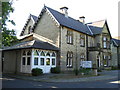
Wilton House Care Home Darlington
Wilton House built for Ann Allan in 1867 now a Care Home
Image: © Peter Robinson
Taken: 30 May 2009
0.20 miles
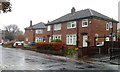
6
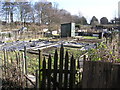
Hummersknott Allotments . off Cemetery Lane
Image: © Hugh Mortimer
Taken: 8 Feb 2006
0.22 miles