IMAGES TAKEN NEAR TO
Larchfield Street, DARLINGTON, DL3 7TE
Introduction
This page details the photographs taken nearby to Larchfield Street, DL3 7TE by members of the Geograph project.
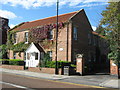
The Geograph project started in 2005 with the aim of publishing, organising and preserving representative images for every square kilometre of Great Britain, Ireland and the Isle of Man.

There are currently over 7.5m images from over14,400 individuals and you can help contribute to the project by visiting https://www.geograph.org.uk
Image Map
Images are licensed for reuse under creativecommons.org/licenses/by-sa/2.0
Notes
- Clicking on the map will re-center to the selected point.
- The higher the marker number, the further away the image location is from the centre of the postcode.
Image Listing (126 Images Found)
Images are licensed for reuse under creativecommons.org/licenses/by-sa/2.0
Image
Details
Distance
1
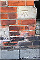
Benchmark on #45 Duke Street
Ordnance Survey cut mark benchmark described on the Bench Mark Database at http://www.bench-marks.org.uk/bm78556
Image: © Roger Templeman
Taken: 26 Aug 2016
0.02 miles
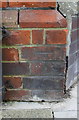
2
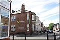
Venture Properties at junction of Duke Street and Larchfield Street
There is an OS benchmark Image on a stone at the front corner of the building, just visible through the railings
Image: © Roger Templeman
Taken: 26 Aug 2016
0.02 miles
3
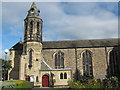
St Augustine's Church Darlington
Opened in 1827 and extended in 1865, Coniscliffe Road
Image: © Peter Robinson
Taken: 24 Sep 2009
0.07 miles
4
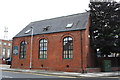
Trinity Hall, Portland Place
The building is occupied by J.& R.M.Richardson Construction (Darlington) Ltd. and has an OS benchmark Image on its front face at the right hand corner, right of a black downpipe
Image: © Roger Templeman
Taken: 6 Sep 2016
0.10 miles
5
Benchmark on Trinity Hall, Portland Place
Ordnance Survey cut mark benchmark described on the Bench Mark Database at http://www.bench-marks.org.uk/bm78666
Image: © Roger Templeman
Taken: 6 Sep 2016
0.10 miles
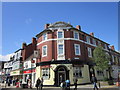
6
Entrance to Burns Yard , Darlington
Burns Yard is an old close opening off Skinnergate in the town centre. It has medieval origins. I believe the building here is C18.
Image: © Robert Graham
Taken: 7 Jun 2018
0.11 miles
8
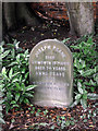
Headstone of Joseph Pease in Darlington Friends' Burial Ground
Joseph Pease was a member of the influential Darlington Quaker family and a wool manufacturer. He was an activist in the anti-slavery movement and took particular interest in abolishing slavery in India. He was a delegate at the World Anti-Slavery Convention in 1840 and a sitter for Haydon's painting of the event http://en.wikipedia.org/wiki/File:The_Anti-Slavery_Society_Convention,_1840_by_Benjamin_Robert_Haydon.jpg. He was a brother of the railway pioneer, Edward Pease, who was the main financier of the Stockton & Darlington Railway.
Image: © John Lucas
Taken: 17 Aug 2012
0.11 miles
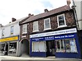
9
Hogarth Court Darlington
Darlington Housing Association flats for the elderly and disabled
Image: © Peter Robinson
Taken: 23 Sep 2009
0.12 miles
10
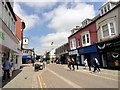
Looking along Skinnergate in Darlington
This is one of the main shopping streets in the town centre. It was part of the old medieval town, which is where the name comes from. It means the street of the tanners. Gate meaning a street in Norse and is common in northern English towns which were once part of the Viking settlements in the early middle ages. The present buildings are all C19 or later. View is looking north to the junction with Duke Street on the left.
Image: © Robert Graham
Taken: 7 Jun 2018
0.12 miles