IMAGES TAKEN NEAR TO
Skinnergate, DARLINGTON, DL3 7LH
Introduction
This page details the photographs taken nearby to Skinnergate, DL3 7LH by members of the Geograph project.
The Geograph project started in 2005 with the aim of publishing, organising and preserving representative images for every square kilometre of Great Britain, Ireland and the Isle of Man.

There are currently over 7.5m images from over14,400 individuals and you can help contribute to the project by visiting https://www.geograph.org.uk
Image Map
Images are licensed for reuse under creativecommons.org/licenses/by-sa/2.0
Notes
- Clicking on the map will re-center to the selected point.
- The higher the marker number, the further away the image location is from the centre of the postcode.
Image Listing (194 Images Found)
Images are licensed for reuse under creativecommons.org/licenses/by-sa/2.0
Image
Details
Distance
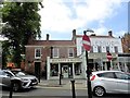
1
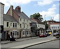
The Turks Head, Darlington
On the south side of Bondgate in the town centre. The 3 storey building is late C17, and the 2 storey part is C18.
Image: © Robert Graham
Taken: 7 Jun 2018
0.02 miles
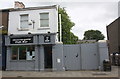
3
The north end of Skinnergate, Darlington
The Tanners Hall, here on the right, is a modern Wetherspoon's pub, but commemorates the medieval origins of the street. The skinners were the tanners and gate is the Viking name for a street. View is looking north towards the junction with Bondgate.
Image: © Robert Graham
Taken: 7 Jun 2018
0.03 miles
4
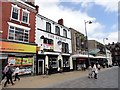
Skinnergate Fish Bar
There is an OS benchmark Image on the right hand gate pier left of the litter bin
Image: © Roger Templeman
Taken: 6 Sep 2016
0.04 miles
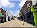
5
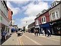
Looking along Skinnergate in Darlington
This is one of the main shopping streets in the town centre. It was part of the old medieval town, which is where the name comes from. It means the street of the tanners. Gate meaning a street in Norse and is common in northern English towns which were once part of the Viking settlements in the early middle ages. The present buildings are all C19 or later. View is looking north to the junction with Duke Street on the left.
Image: © Robert Graham
Taken: 7 Jun 2018
0.04 miles
7
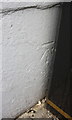
Benchmark on wall pier, Skinnergate
Ordnance Survey cut mark benchmark described on the Bench Mark Database at http://www.bench-marks.org.uk/bm78576
Image: © Roger Templeman
Taken: 6 Sep 2016
0.05 miles
8
Old houses on Bondgate, Darlington
These 2 shops were originally early C18 houses. They are at the west end of Bondgate, in the town centre. The pantile roofs are a bit of a giveaway; not what you would normally see in a town centre.
Image: © Robert Graham
Taken: 7 Jun 2018
0.05 miles
9
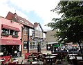
Pavement cafes on Bondgate, Darlington
Two outside seating areas for the Tapas Bar and the Old English Gentleman pub next door. These are becoming commoner in English towns these days. The summer of 2018 when this shot was taken was of course particularly suitable.
Image: © Robert Graham
Taken: 7 Jun 2018
0.05 miles
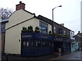
10
The George, Darlington
This old pub is on Bondgate, in the town centre. Bondgate is medieval in origin, as its name suggests, but the surviving buildings are of later date. This fine old pub is early C19.
Image: © Robert Graham
Taken: 7 Jun 2018
0.05 miles