IMAGES TAKEN NEAR TO
Stanhope Road North, DARLINGTON, DL3 7AP
Introduction
This page details the photographs taken nearby to Stanhope Road North, DL3 7AP by members of the Geograph project.
The Geograph project started in 2005 with the aim of publishing, organising and preserving representative images for every square kilometre of Great Britain, Ireland and the Isle of Man.

There are currently over 7.5m images from over14,400 individuals and you can help contribute to the project by visiting https://www.geograph.org.uk
Image Map
Images are licensed for reuse under creativecommons.org/licenses/by-sa/2.0
Notes
- Clicking on the map will re-center to the selected point.
- The higher the marker number, the further away the image location is from the centre of the postcode.
Image Listing (47 Images Found)
Images are licensed for reuse under creativecommons.org/licenses/by-sa/2.0
Image
Details
Distance
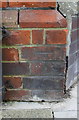
1

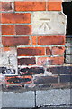
Benchmark on park wall, Stanhope Road North
Ordnance Survey cut mark benchmark described on the Bench Mark Database at http://www.bench-marks.org.uk/bm78555
Image: © Roger Templeman
Taken: 26 Aug 2016
0.03 miles
2
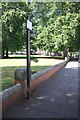
Boundary wall of Stanhope Gardens, Stanhope Road North
There is an OS benchmark Image on a stone in the wall pier left of the post of the parking restriction sign
Image: © Roger Templeman
Taken: 26 Aug 2016
0.03 miles
3
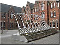
Threshold Darlington
A kinetic water sculpture in front of the Arts Centre
Image: © Peter Robinson
Taken: 6 Apr 2010
0.08 miles
4
Benchmark on Trinity Hall, Portland Place
Ordnance Survey cut mark benchmark described on the Bench Mark Database at http://www.bench-marks.org.uk/bm78666
Image: © Roger Templeman
Taken: 6 Sep 2016
0.09 miles
5
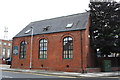
Trinity Hall, Portland Place
The building is occupied by J.& R.M.Richardson Construction (Darlington) Ltd. and has an OS benchmark Image on its front face at the right hand corner, right of a black downpipe
Image: © Roger Templeman
Taken: 6 Sep 2016
0.09 miles
7
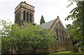
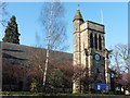
Holy Trinity Parish Church, Woodland Road
There is an OS benchmark Image on a buttress at the far corner of the tower and the pinnacle just visible above the far corner of the tower is an OS intersected station trig point, http://trigpointing.uk/trig/9004
Image: © Roger Templeman
Taken: 6 Sep 2016
0.11 miles
8
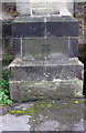
Benchmark on Holy Trinity Parish Church
Ordnance Survey cut mark benchmark described on the Bench Mark Database at http://www.bench-marks.org.uk/bm78667
Image: © Roger Templeman
Taken: 6 Sep 2016
0.11 miles

10
Benchmark on #45 Duke Street
Ordnance Survey cut mark benchmark described on the Bench Mark Database at http://www.bench-marks.org.uk/bm78556
Image: © Roger Templeman
Taken: 26 Aug 2016
0.12 miles