IMAGES TAKEN NEAR TO
Corporation Road, DARLINGTON, DL3 6AR
Introduction
This page details the photographs taken nearby to Corporation Road, DL3 6AR by members of the Geograph project.
The Geograph project started in 2005 with the aim of publishing, organising and preserving representative images for every square kilometre of Great Britain, Ireland and the Isle of Man.

There are currently over 7.5m images from over14,400 individuals and you can help contribute to the project by visiting https://www.geograph.org.uk
Image Map
Images are licensed for reuse under creativecommons.org/licenses/by-sa/2.0
Notes
- Clicking on the map will re-center to the selected point.
- The higher the marker number, the further away the image location is from the centre of the postcode.
Image Listing (51 Images Found)
Images are licensed for reuse under creativecommons.org/licenses/by-sa/2.0
Image
Details
Distance
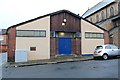
1
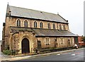
Railway Pioneers Memorial Church, Darlington
On Corporation Road.
Not far from North Road Railway Station and the heart of the railway works.
Image]
Image: © Bob Embleton
Taken: 30 Aug 2012
0.11 miles
2
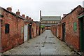
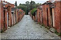
Back Lane (looking south), Hope Town, Darlington
The blue cobbled lane runs behind the terraced houses of Barningham Street and Marshall Street.
Each house has a small back yard - no garden.
Note the shoulder height coal doors for convenient delivery.
Some of the yards have been adapted by fitting wide doors to allow vehicle parking.
At the top of the streets there is the Railway Pioneers' Memorial Church.
Image]
Image]
Image]
Image: © Bob Embleton
Taken: 30 Aug 2012
0.11 miles
3
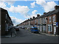
Bartlett Street in Darlington
Seen from across Widdowfield Street looking south. G.W.Bartlett was Mayor of Darlington 1893-1894; John Widdowfield served his term as mayor in 1897-98.
Image: © Peter Robinson
Taken: 24 Jun 2011
0.12 miles
4
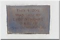
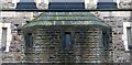
Foundation Stone
On the hall beside the Railway Pioneers Memorial Church.
This stone was laid by
Lady Starmer O.B.E. J.P.
15th October 1961
Image]
Image]
Image: © Bob Embleton
Taken: 30 Aug 2012
0.12 miles
5
Church Hall?, Barningham Street, Darlington
Next door to The Railway Pioneers Memorial Church.
The foundation stone was laid by Lady Starmer O.B.E. J.P. on the 15th of October 1961.
Image]
Image]
Image: © Bob Embleton
Taken: 30 Aug 2012
0.12 miles
6
Railway Pioneers Memorial Church (detail), Darlington
Image: © Bob Embleton
Taken: 30 Aug 2012
0.12 miles
7
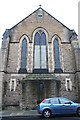
Railway Pioneers Memorial Church (west end), Darlington
The west end of the church on Barningham Street.
The name of the church is carved on the stones just below window level.
Image]
Image]
Image: © Bob Embleton
Taken: 30 Aug 2012
0.12 miles
8
Back Lane (looking north), Hope Town, Darlington
The blue cobbled lane runs behind the terraced houses of Barningham Street and Marshall Street.
Each house has a small back yard - no garden.
Image]
Image]
Image: © Bob Embleton
Taken: 30 Aug 2012
0.13 miles
9
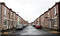
Barningham Street (from the south), Hope Town
One of a many parallel streets of terraced houses.
Possible built to house workers for the railway works in the Victorian era.
No gardens - just a small back yard with access to a back lane.
Note the satellite dishes on many of the houses on the right hand side.
Also note the "sleeping policeman" traffic calming "speed bump" half way up the street.
Image]
Image]
Image: © Bob Embleton
Taken: 30 Aug 2012
0.13 miles
10
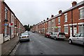
Barningham Street, (looking north) Hope Town, Darlington
One of a many parallel streets of terraced houses.
Possible built to house workers for the railway works in the Victorian era.
No gardens - just a small back yard with access to a back lane.Image]
Image]
Image: © Bob Embleton
Taken: 30 Aug 2012
0.14 miles