IMAGES TAKEN NEAR TO
Bowen Road, DARLINGTON, DL3 0TH
Introduction
This page details the photographs taken nearby to Bowen Road, DL3 0TH by members of the Geograph project.
The Geograph project started in 2005 with the aim of publishing, organising and preserving representative images for every square kilometre of Great Britain, Ireland and the Isle of Man.

There are currently over 7.5m images from over14,400 individuals and you can help contribute to the project by visiting https://www.geograph.org.uk
Image Map
Images are licensed for reuse under creativecommons.org/licenses/by-sa/2.0
Notes
- Clicking on the map will re-center to the selected point.
- The higher the marker number, the further away the image location is from the centre of the postcode.
Image Listing (9 Images Found)
Images are licensed for reuse under creativecommons.org/licenses/by-sa/2.0
Image
Details
Distance
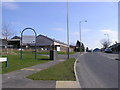
1
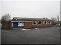
Bowen Road Community Centre Darlington
A basic exterior without identity signage
Image: © Peter Robinson
Taken: 19 Jan 2010
0.03 miles
2
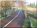
Bridge for multi-user route over West Beck
Image: © Peter Robinson
Taken: 23 Dec 2012
0.11 miles
5
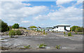
Disused site at Faverdale Industrial Estate
The Faverdale Industrial Estate lies to the north-west of Darlington. All that remains at the site is a large area of concrete and piles of rubble.
Image: © Trevor Littlewood
Taken: 10 May 2017
0.16 miles
7
Road to Sans Pareil Square crossing West Beck in Darlington
Image: © Peter Robinson
Taken: 24 Apr 2012
0.18 miles
9
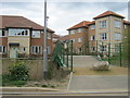
Footbridge from George Stephenson Drive to cross West Beck in Darlington
Image: © Peter Robinson
Taken: 24 Apr 2012
0.25 miles