IMAGES TAKEN NEAR TO
Faverdale North, DARLINGTON, DL3 0PX
Introduction
This page details the photographs taken nearby to Faverdale North, DL3 0PX by members of the Geograph project.
The Geograph project started in 2005 with the aim of publishing, organising and preserving representative images for every square kilometre of Great Britain, Ireland and the Isle of Man.

There are currently over 7.5m images from over14,400 individuals and you can help contribute to the project by visiting https://www.geograph.org.uk
Image Map
Images are licensed for reuse under creativecommons.org/licenses/by-sa/2.0
Notes
- Clicking on the map will re-center to the selected point.
- The higher the marker number, the further away the image location is from the centre of the postcode.
Image Listing (1 Images Found)
Images are licensed for reuse under creativecommons.org/licenses/by-sa/2.0
Image
Details
Distance
1
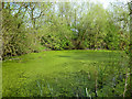
Weedy pond by Faverdale Black Path
The bridleway from Rise Carr to Faverdale, passes between Faverdale Industrial Estate to the north and residential areas of north Darlington to the south. A triangle and long strip of secondary woodland acts to some as extent as a barrier to the noise of the former and provide a habitat for wildlife, despite the urban decay just beyond the trees. This pond, heavily choked with duckweed, was seething with tadpoles, whilst there was much birdsong as the local species no doubt found plenty of invertebrates to eat among the decaying wood.
Image: © Andy Waddington
Taken: 23 Apr 2014
0.25 miles