IMAGES TAKEN NEAR TO
Garden Place, DARLINGTON, DL3 0HF
Introduction
This page details the photographs taken nearby to Garden Place, DL3 0HF by members of the Geograph project.
The Geograph project started in 2005 with the aim of publishing, organising and preserving representative images for every square kilometre of Great Britain, Ireland and the Isle of Man.

There are currently over 7.5m images from over14,400 individuals and you can help contribute to the project by visiting https://www.geograph.org.uk
Image Map
Images are licensed for reuse under creativecommons.org/licenses/by-sa/2.0
Notes
- Clicking on the map will re-center to the selected point.
- The higher the marker number, the further away the image location is from the centre of the postcode.
Image Listing (16 Images Found)
Images are licensed for reuse under creativecommons.org/licenses/by-sa/2.0
Image
Details
Distance
4
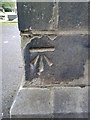
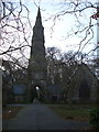
Ordnance Survey Cut Mark
This can be found on the chapel wall in North Cemetery.
Image: © Peter Wood
Taken: 5 Oct 2013
0.14 miles
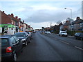
6
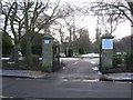
Entrance to North Cemetery Darlington
Seen from Thompson Street West
Image: © Peter Robinson
Taken: 22 Feb 2010
0.16 miles
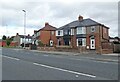
9
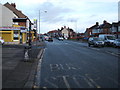
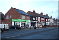
Bus stop on North Road (A167)
Looking north.
Image: © JThomas
Taken: 28 Nov 2015
0.17 miles
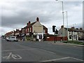
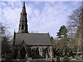
10
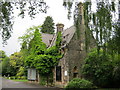
Former home of the Superintendent in North Cemetery Darlington
Image: © Peter Robinson
Taken: 19 Jun 2011
0.22 miles