IMAGES TAKEN NEAR TO
Piercebridge, DARLINGTON, DL2 3SR
Introduction
This page details the photographs taken nearby to DL2 3SR by members of the Geograph project.
The Geograph project started in 2005 with the aim of publishing, organising and preserving representative images for every square kilometre of Great Britain, Ireland and the Isle of Man.

There are currently over 7.5m images from over14,400 individuals and you can help contribute to the project by visiting https://www.geograph.org.uk
Image Map
Images are licensed for reuse under creativecommons.org/licenses/by-sa/2.0
Notes
- Clicking on the map will re-center to the selected point.
- The higher the marker number, the further away the image location is from the centre of the postcode.
Image Listing (9 Images Found)
Images are licensed for reuse under creativecommons.org/licenses/by-sa/2.0
Image
Details
Distance
1
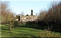
Cliffe Hall
Cliffe Hall appears to be a 19th century rebuild of a much older house. Presumably it is not considered to be of great architectural or historic merit as it doesn't appear on the listed buildings of North Yorkshire website.
Image: © Gordon Hatton
Taken: 28 Jan 2019
0.01 miles
2
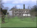
Cliffe Hall
Cliffe Hall : Undergoing a rebuild after a serious fire in 2005.
Image: © Hugh Mortimer
Taken: 29 Mar 2006
0.01 miles
3
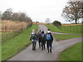
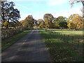
Walkers passing the entrance to Cliffe Hall, Piercebridge
This photograph shows a group of walkers passing the entrance to Cliffe Hall ( Image ) as they make their way in a westerly direction towards Low Field Cottage. The wrought-iron fencing shown in this picture is a characteristic feature of the boundary fences surrounding Cliffe Hall.
Image: © Philip Barker
Taken: 13 Dec 2009
0.17 miles
4
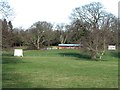
Cliffe Park and cricket ground
Parkland and cricket ground close to Cliffe Hall.
Image: © Gordon Hatton
Taken: 28 Jan 2019
0.18 miles
5
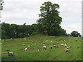
Betty Watson's Hill : Tumulus
One of three Tumuli in the area. One sited at Carlbury north of the River Tees, known as Smotherlaw (NZ2116)
Image: © Hugh Mortimer
Taken: 23 Jun 2006
0.18 miles
7
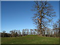
Betty Watson's Hill
A rather unremarkable small lump crowned by a large tree. The lump is a Bronze Age bowl barrow which was excavated in 1904. One assumes that Betty Watson was not around in the Bronze Age, but might have been a resident of nearby Cliffe Hall.
Image: © Gordon Hatton
Taken: 28 Jan 2019
0.21 miles
8
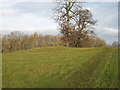
Betty Watson's Hill near Piercebridge
Much of the land in this locality is quite flat. One exception to this is Betty Watson's Hill (shown here) which lies just to the east of Cliffe Hall. This photograph was taken from the public footpath (which runs over the hill) looking in a northerly direction towards Piercebridge. The River Tees lies just beyond the trees that can be seen in the background of the picture.
Image: © Philip Barker
Taken: 13 Dec 2009
0.22 miles
9
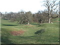
Curious depression in Cliffe Park
A grassy trough that runs for some distance across Cliffe Park and parallel with the footpath. One source suggests that it may be the remains of a park pale. although a cobbled surface has been found beneath the surface.
Image: © Gordon Hatton
Taken: 28 Jan 2019
0.25 miles