IMAGES TAKEN NEAR TO
Cliffe Bank, DARLINGTON, DL2 3SP
Introduction
This page details the photographs taken nearby to Cliffe Bank, DL2 3SP by members of the Geograph project.
The Geograph project started in 2005 with the aim of publishing, organising and preserving representative images for every square kilometre of Great Britain, Ireland and the Isle of Man.

There are currently over 7.5m images from over14,400 individuals and you can help contribute to the project by visiting https://www.geograph.org.uk
Image Map
Images are licensed for reuse under creativecommons.org/licenses/by-sa/2.0
Notes
- Clicking on the map will re-center to the selected point.
- The higher the marker number, the further away the image location is from the centre of the postcode.
Image Listing (15 Images Found)
Images are licensed for reuse under creativecommons.org/licenses/by-sa/2.0
Image
Details
Distance
2
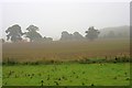
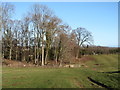
Betty Watson's Hill near Piercebridge
Much of the land in this locality is quite flat. One exception to this is Betty Watson's Hill (shown here) which lies just to the east of Cliffe Hall. This photograph was taken from the public footpath (which runs over the hill) looking in a northerly direction towards Piercebridge. The River Tees lies just beyond the trees that can be seen in the background of the picture.
Image: © Philip Barker
Taken: 13 Dec 2009
0.17 miles
3
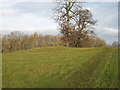
Betty Watson's Hill
A rather unremarkable small lump crowned by a large tree. The lump is a Bronze Age bowl barrow which was excavated in 1904. One assumes that Betty Watson was not around in the Bronze Age, but might have been a resident of nearby Cliffe Hall.
Image: © Gordon Hatton
Taken: 28 Jan 2019
0.18 miles
4
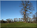
Betty Watson's Hill : Tumulus
One of three Tumuli in the area. One sited at Carlbury north of the River Tees, known as Smotherlaw (NZ2116)
Image: © Hugh Mortimer
Taken: 23 Jun 2006
0.19 miles
5
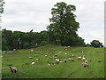
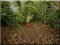
Path approaching Kathleen Wood
Footpath heading for a strip of woodland on the southern banks of the Tees. Fields and parkland here show extensive areas of ridge and furrow, which suggests that the tiny settlement of Cliffe may have been much larger at some time in the past.
Image: © Gordon Hatton
Taken: 28 Jan 2019
0.21 miles
6
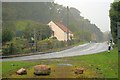
Cliffe
A hamlet on the Yorkshire side of the River Tees.
Image: © Mick Garratt
Taken: 3 Oct 2013
0.22 miles
7
![Piercebridge Roman features [1]](https://s0.geograph.org.uk/geophotos/07/31/89/7318920_88671c65_120x120.jpg)
Piercebridge Roman features [1]
This information board about the Roman Bridge is located in the car park.
Piercebridge is a village in the county of Durham, some 5 miles west of Darlington. The village overlies a Roman fort built circa 265 where Dere Street, the Roman road from York to Newstead, crossed the River Tees. The fort was occupied until the fifth century and a civilian settlement was established to the east of the fort. The river has changed course and the remains of a Roman bridge over the river lie about a quarter of a mile east of the current bridge. Most of the site of the village is a Scheduled Ancient Monument, with details at: https://historicengland.org.uk/listing/the-list/list-entry/1002365
Image: © Michael Dibb
Taken: 23 Jun 2022
0.22 miles
8
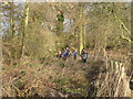
Walkers coming through Kathleen Wood, Piercebridge
This photograph shows a group of walkers coming through Kathleen Wood near Piercebridge. The footpath they are on runs in a southerly direction from near the George Hotel (on the B6275) to meet the access track that runs west from Cliffe Bank (again on the B6275 road).
Image: © Philip Barker
Taken: 13 Dec 2009
0.22 miles
9
Path to the Roman Bridge, Piercebridge
Image: © Humphrey Bolton
Taken: 6 Nov 2022
0.23 miles
10
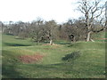
Curious depression in Cliffe Park
A grassy trough that runs for some distance across Cliffe Park and parallel with the footpath. One source suggests that it may be the remains of a park pale. although a cobbled surface has been found beneath the surface.
Image: © Gordon Hatton
Taken: 28 Jan 2019
0.23 miles