IMAGES TAKEN NEAR TO
High Garth, DARLINGTON, DL2 3RY
Introduction
This page details the photographs taken nearby to High Garth, DL2 3RY by members of the Geograph project.
The Geograph project started in 2005 with the aim of publishing, organising and preserving representative images for every square kilometre of Great Britain, Ireland and the Isle of Man.

There are currently over 7.5m images from over14,400 individuals and you can help contribute to the project by visiting https://www.geograph.org.uk
Image Map
Images are licensed for reuse under creativecommons.org/licenses/by-sa/2.0
Notes
- Clicking on the map will re-center to the selected point.
- The higher the marker number, the further away the image location is from the centre of the postcode.
Image Listing (18 Images Found)
Images are licensed for reuse under creativecommons.org/licenses/by-sa/2.0
Image
Details
Distance
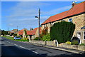
3
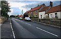
Winston Village main street
Formerly the A67, before a by-pass was built.
Image: © Stanley Howe
Taken: 5 Jun 2007
0.09 miles
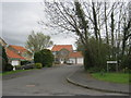
4
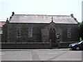
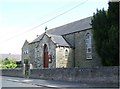
Winston : Methodist Church
On the west side of the village, dated 1902.
Image: © Hugh Mortimer
Taken: 10 Jun 2006
0.10 miles
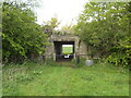
6
Public footpath leading north from Winston via Town Farm Close
Image: © Peter Robinson
Taken: 9 Apr 2012
0.11 miles
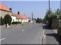
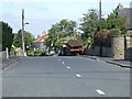
7
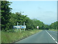
West access to Winston village
From A67.
Image: © Stanley Howe
Taken: 5 Jun 2007
0.12 miles