IMAGES TAKEN NEAR TO
Winston, DARLINGTON, DL2 3RR
Introduction
This page details the photographs taken nearby to DL2 3RR by members of the Geograph project.
The Geograph project started in 2005 with the aim of publishing, organising and preserving representative images for every square kilometre of Great Britain, Ireland and the Isle of Man.

There are currently over 7.5m images from over14,400 individuals and you can help contribute to the project by visiting https://www.geograph.org.uk
Image Map
Images are licensed for reuse under creativecommons.org/licenses/by-sa/2.0
Notes
- Clicking on the map will re-center to the selected point.
- The higher the marker number, the further away the image location is from the centre of the postcode.
Image Listing (39 Images Found)
Images are licensed for reuse under creativecommons.org/licenses/by-sa/2.0
Image
Details
Distance
1
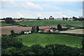
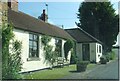
Winston Gate
Winston Gate seen from Winston.
Image: © Peter McDermott
Taken: 2 Sep 2011
0.01 miles
2
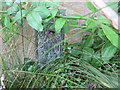
Ordnance Survey Flush Bracket 2217
This can be found on the wall of a private dwelling at Winston Gate.
For more detail see : http://www.bench-marks.org.uk/bm67
Image: © Peter Wood
Taken: 15 Jul 2015
0.02 miles
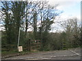
3
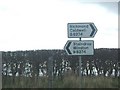
Winston-Richmond road at Winston gate
Road sign at Ovington road junction
Image: © Stanley Howe
Taken: 8 Apr 2006
0.02 miles
4
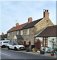
Winston Gate, Old Inn Cottage
There is OS Flush Bracket 2217 embedded into the west facing wall of the cottage which previously had been an Inn.
Image: © Mel Towler
Taken: 8 Feb 2023
0.02 miles
5
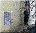
Winston Gate, Old Inn Cottage
The OS Flush Bracket 2217 is embedded into the west facing wall of the cottage which previously had been an Inn.
Image: © Mel Towler
Taken: 8 Feb 2023
0.03 miles
7
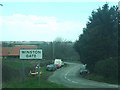
Winston Gate
Start of descent to Winston Bridge
Image: © Stanley Howe
Taken: 8 Apr 2006
0.05 miles
8
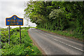
B6274 climbing away from Winston Bridge, with road sign
The road passes the blue and yellow road sign naming the settlement, (Winston Gate), about to be entered; it's in the livery used commonly in County Durham for such signs. This one is a little discoloured by the growth of algae!
Image: © Trevor Littlewood
Taken: 19 May 2020
0.09 miles
10
Entrance to public bridleway on the southern side of the River Tees
Image: © Peter Robinson
Taken: 18 Mar 2012
0.14 miles