IMAGES TAKEN NEAR TO
Staindrop Road, DARLINGTON, DL2 3QH
Introduction
This page details the photographs taken nearby to Staindrop Road, DL2 3QH by members of the Geograph project.
The Geograph project started in 2005 with the aim of publishing, organising and preserving representative images for every square kilometre of Great Britain, Ireland and the Isle of Man.

There are currently over 7.5m images from over14,400 individuals and you can help contribute to the project by visiting https://www.geograph.org.uk
Image Map
Images are licensed for reuse under creativecommons.org/licenses/by-sa/2.0
Notes
- Clicking on the map will re-center to the selected point.
- The higher the marker number, the further away the image location is from the centre of the postcode.
Image Listing (9 Images Found)
Images are licensed for reuse under creativecommons.org/licenses/by-sa/2.0
Image
Details
Distance
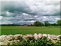
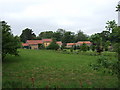
2
Battery pens by Alwent Hall
No stock visible.
Image: © Stanley Howe
Taken: 5 Jun 2007
0.17 miles
3
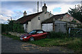
Toll Gate Cottage
Toll Gate Cottage alongside the B6274 between Staindrop and Winston.
Image: © Peter McDermott
Taken: 2 Sep 2011
0.18 miles
5
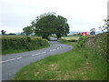
B6274 wending towards Staindrop
From the Selaby junction.
Image: © Stanley Howe
Taken: 5 Jun 2007
0.19 miles
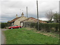
6

B6274 heading north towards Staindrop
The B road winding north beyond Toll Gate Cottage passing between two leafless, deciduous trees.
Image: © Trevor Littlewood
Taken: 18 Jan 2022
0.20 miles
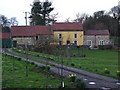
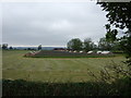
9
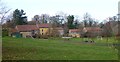
Alwent Mill
Now more residential than industrial, Alwent Mill formerly used water from weirs upstream on Langley Beck a short distance beyond the buildings seen here.
Image: © Andy Waddington
Taken: 16 Feb 2011
0.21 miles