IMAGES TAKEN NEAR TO
Middlehope Way, DARLINGTON, DL2 2ZE
Introduction
This page details the photographs taken nearby to Middlehope Way, DL2 2ZE by members of the Geograph project.
The Geograph project started in 2005 with the aim of publishing, organising and preserving representative images for every square kilometre of Great Britain, Ireland and the Isle of Man.

There are currently over 7.5m images from over14,400 individuals and you can help contribute to the project by visiting https://www.geograph.org.uk
Image Map
Images are licensed for reuse under creativecommons.org/licenses/by-sa/2.0
Notes
- Clicking on the map will re-center to the selected point.
- The higher the marker number, the further away the image location is from the centre of the postcode.
Image Listing (6 Images Found)
Images are licensed for reuse under creativecommons.org/licenses/by-sa/2.0
Image
Details
Distance
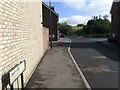
3
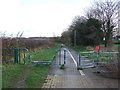
Cycle path on disused railway
Looking east from Newton Lane.
Image: © JThomas
Taken: 6 Dec 2015
0.13 miles
4
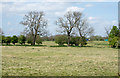
Trees across field near from Newton Lane
The field is on the west side of Newton Lane to the north-west of Darlington.
Image: © Trevor Littlewood
Taken: 10 May 2017
0.18 miles
6
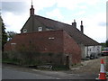
Stag House : Newton Lane
A sundial on the south wall inscribed : John & Eliz Ward ,1763
Image: © Hugh Mortimer
Taken: 1 May 2006
0.21 miles