IMAGES TAKEN NEAR TO
West Auckland Road, DARLINGTON, DL2 2YH
Introduction
This page details the photographs taken nearby to West Auckland Road, DL2 2YH by members of the Geograph project.
The Geograph project started in 2005 with the aim of publishing, organising and preserving representative images for every square kilometre of Great Britain, Ireland and the Isle of Man.

There are currently over 7.5m images from over14,400 individuals and you can help contribute to the project by visiting https://www.geograph.org.uk
Image Map
Images are licensed for reuse under creativecommons.org/licenses/by-sa/2.0
Notes
- Clicking on the map will re-center to the selected point.
- The higher the marker number, the further away the image location is from the centre of the postcode.
Image Listing (5 Images Found)
Images are licensed for reuse under creativecommons.org/licenses/by-sa/2.0
Image
Details
Distance
1
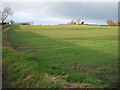
Humbleton Farm
Taken from a Public Footpath. A new Darlington Cattle Market and Agricultural Centre is proposed for construction on this farm.
Image: © Hugh Mortimer
Taken: 4 Aug 2006
0.11 miles
3
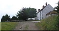
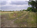
Headland footpath just east of Humbleton Farm
Image: © Peter Robinson
Taken: 22 Aug 2012
0.16 miles
4
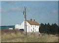
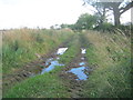
Footpath : Humbleton Farm
Footpath from Humbleton Farm to Whiley Hill disused sand pit, crossing the A1(M) and on to Patches Lane
Image: © Hugh Mortimer
Taken: 4 Aug 2006
0.16 miles