IMAGES TAKEN NEAR TO
Heighington, DARLINGTON, DL2 2XQ
Introduction
This page details the photographs taken nearby to DL2 2XQ by members of the Geograph project.
The Geograph project started in 2005 with the aim of publishing, organising and preserving representative images for every square kilometre of Great Britain, Ireland and the Isle of Man.

There are currently over 7.5m images from over14,400 individuals and you can help contribute to the project by visiting https://www.geograph.org.uk
Image Map
Images are licensed for reuse under creativecommons.org/licenses/by-sa/2.0
Notes
- Clicking on the map will re-center to the selected point.
- The higher the marker number, the further away the image location is from the centre of the postcode.
Image Listing (12 Images Found)
Images are licensed for reuse under creativecommons.org/licenses/by-sa/2.0
Image
Details
Distance
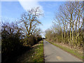
2
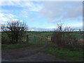
Farm track (footpath) to Primrose Farm
Off White House Lane.
Image: © JThomas
Taken: 6 Dec 2015
0.05 miles
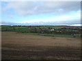
3
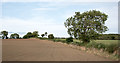
Field edge adjacent to White House Lane
A crop - its nature unknown - is beginning to emerge - green shoots - from the soil of the field which lies north of the A68 at Houghton Bank. White House Lane is on the other side of the hedge.
Image: © Trevor Littlewood
Taken: 28 Sep 2016
0.14 miles
4
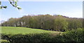
Shackleton Beacon Hill, Redworth Woods
West of Redworth Hall. In the 18th century a windmill stood on the summit of the Iron Age (800BC-AD43) hillfort of Shackleton Beacon. Although now covered in trees the presence of a windmill means they must once have been cleared. The remains of the windmill were turned into a gazebo, folly (1794). The ruined remains of the site survive with some details of windows and plaster still to be seen.
Image: © Hugh Mortimer
Taken: 3 May 2006
0.15 miles
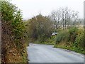
6
Lane towards Todd Fall Farm
Looking north east.
Image: © JThomas
Taken: 6 Dec 2015
0.18 miles
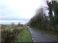
8
Park House Lane near Heighington
Viewed from the junction with White House Lane.
Image: © pam fray
Taken: 19 Sep 2018
0.21 miles
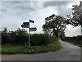
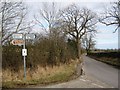
9
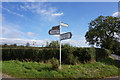
Junction of White House and Park Lanes
Straight on [north] for White House Farm, right [east] for Park House.
Image: © Christine Johnstone
Taken: 23 Oct 2012
0.21 miles
10
Park House Lane near Heighington
Seen from White House Lane
Image: © Peter Robinson
Taken: 11 Mar 2010
0.23 miles