IMAGES TAKEN NEAR TO
West Close, DARLINGTON, DL2 2LN
Introduction
This page details the photographs taken nearby to West Close, DL2 2LN by members of the Geograph project.
The Geograph project started in 2005 with the aim of publishing, organising and preserving representative images for every square kilometre of Great Britain, Ireland and the Isle of Man.

There are currently over 7.5m images from over14,400 individuals and you can help contribute to the project by visiting https://www.geograph.org.uk
Image Map
Images are licensed for reuse under creativecommons.org/licenses/by-sa/2.0
Notes
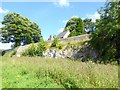
- Clicking on the map will re-center to the selected point.
- The higher the marker number, the further away the image location is from the centre of the postcode.
Image Listing (24 Images Found)
Images are licensed for reuse under creativecommons.org/licenses/by-sa/2.0
Image
Details
Distance
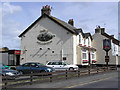
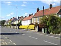
3
High Coniscliffe
Situated next to the River Tees just 4 miles west of Darlington.
Image: © Peter Robinson
Taken: 19 Jun 2009
0.07 miles
4
Bend on the River Tees
The well-wooded steep banks on the outside of the bend includes one of the rocky outcrops which puts the cliff into High Coniscliffe.
Image: © Oliver Dixon
Taken: 10 Aug 2017
0.09 miles
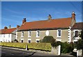
5
Cottages at High Coniscliffe
Flanking the A67 Darlington to Barnard Castle road. The Teesdale Way, a 148 km long path which runs from Dufton in Cumbria through to the Tees estuary, follows the main road at this point.
Image: © Oliver Dixon
Taken: 10 Aug 2017
0.09 miles
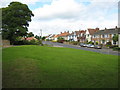
6
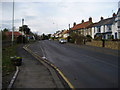
High Coniscliffe
The A67 running through the centre of this community, beside the River Tees.
Image: © Chris Heaton
Taken: 4 Nov 2009
0.10 miles
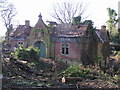
7
Old Hall Farmhouse, High Coniscliffe
The best house in the village is dated as somewhere around the beginning of the 18thC, although there is said to be a medieval wing around the back. Unfortunately a large bush hides the doorway with sundial above.
Image: © Gordon Hatton
Taken: 27 Oct 2017
0.12 miles
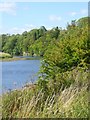
8
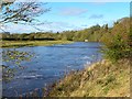
The Tees at High Coniscliffe
The broad, fast flowing Tees just below the village of High Coniscliffe.
Image: © Gordon Hatton
Taken: 22 Oct 2017
0.14 miles
9
Rocky outcrop at High Coniscliffe
One of the rocky outcrops which puts the cliff into High Coniscliffe.
Image: © Oliver Dixon
Taken: 10 Aug 2017
0.16 miles
10
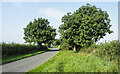
Ulnaby Lane heading north
Ulnaby Lane just outside the small village of High Coniscliffe close to Darlington.
Image: © Trevor Littlewood
Taken: 8 Sep 2023
0.18 miles