IMAGES TAKEN NEAR TO
Creebeck Drive, DARLINGTON, DL2 2JT
Introduction
This page details the photographs taken nearby to Creebeck Drive, DL2 2JT by members of the Geograph project.
The Geograph project started in 2005 with the aim of publishing, organising and preserving representative images for every square kilometre of Great Britain, Ireland and the Isle of Man.

There are currently over 7.5m images from over14,400 individuals and you can help contribute to the project by visiting https://www.geograph.org.uk
Image Map
Images are licensed for reuse under creativecommons.org/licenses/by-sa/2.0
Notes
- Clicking on the map will re-center to the selected point.
- The higher the marker number, the further away the image location is from the centre of the postcode.
Image Listing (3 Images Found)
Images are licensed for reuse under creativecommons.org/licenses/by-sa/2.0
Image
Details
Distance
1
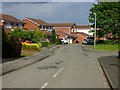
Mowbray Drive, Hurworth
Modern houses off Roundhill Road where the village is undergoing further northwards expansion.
Image: © Andrew Smith
Taken: 24 May 2019
0.17 miles
2
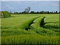
Farmland, Hurworth
Barley to the east of Roundhill Road.
Image: © Andrew Smith
Taken: 24 May 2019
0.20 miles
3
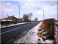
Ashfield Farm
Ashfield is located on the minor road (Roundhill Road) that runs between Hurworth-on-Tees and Darlington. This photograph shows a view of Ashfield looking up the road in a northerly direction towards Darlington.
Image: © Philip Barker
Taken: 10 Jan 2010
0.25 miles