IMAGES TAKEN NEAR TO
Hunt Mews, DARLINGTON, DL2 2GP
Introduction
This page details the photographs taken nearby to Hunt Mews, DL2 2GP by members of the Geograph project.
The Geograph project started in 2005 with the aim of publishing, organising and preserving representative images for every square kilometre of Great Britain, Ireland and the Isle of Man.

There are currently over 7.5m images from over14,400 individuals and you can help contribute to the project by visiting https://www.geograph.org.uk
Image Map
Images are licensed for reuse under creativecommons.org/licenses/by-sa/2.0
Notes
- Clicking on the map will re-center to the selected point.
- The higher the marker number, the further away the image location is from the centre of the postcode.
Image Listing (5 Images Found)
Images are licensed for reuse under creativecommons.org/licenses/by-sa/2.0
Image
Details
Distance
1

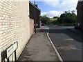
View of West Park Development, Darlington
Hundreds of acres of brown and greenfield land to the west of Darlington have been developed in the last few years. This view is from the Cockerton to Walworth road. The new West Park Psychiatric Hospital dominates to the left of the scene.
Image: © mark harrington
Taken: 17 Nov 2005
0.09 miles
3
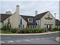
The White Heifer That Travelled
Pub with one of the longest names in Britain. Opened early 21st century in new development named Westpark, Darlington.
Image: © Peter Robinson
Taken: 4 Jun 2009
0.15 miles
4
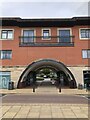
Archway through modern mixed retail and residential development
A mixed development of retail on the ground floor with flats above in the West Park development. Redevelopment of the West Park Village area began in 2002 and includes retail and residential properties, a school, and a nature reserve. the area was formerly the site of a chemical works (Darchem) and adjacent farmland.
Image: © David Robinson
Taken: 23 Oct 2021
0.18 miles
5

Retail development, West Park Village
Modern retail unit at West Park Village, a recent and ongoing development of the West Park area using the former Darchem works site and adjoining farmland.
Image: © David Robinson
Taken: 23 Oct 2021
0.18 miles