IMAGES TAKEN NEAR TO
Timmys Lane, DARLINGTON, DL2 2AJ
Introduction
This page details the photographs taken nearby to Timmys Lane, DL2 2AJ by members of the Geograph project.
The Geograph project started in 2005 with the aim of publishing, organising and preserving representative images for every square kilometre of Great Britain, Ireland and the Isle of Man.

There are currently over 7.5m images from over14,400 individuals and you can help contribute to the project by visiting https://www.geograph.org.uk
Image Map
Images are licensed for reuse under creativecommons.org/licenses/by-sa/2.0
Notes
- Clicking on the map will re-center to the selected point.
- The higher the marker number, the further away the image location is from the centre of the postcode.
Image Listing (35 Images Found)
Images are licensed for reuse under creativecommons.org/licenses/by-sa/2.0
Image
Details
Distance
1
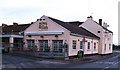
The Otter and Fish
Bar and restaurant at the eastern end of Hurworth. Refitted and upgraded in 2007.
Image: © Gordon Hatton
Taken: 27 Nov 2009
0.09 miles
2
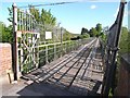
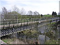
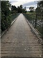
Low Hail Bridge
This bridge carries the bridleway from Low Hail Farm over the Tees to Hurworth. The deck is in very poor condition and a notice at the north end states that the bridge is closed. Fortunately the gate was open, otherwise it would have been a long detour.
Image: © Oliver Dixon
Taken: 12 May 2009
0.10 miles
3
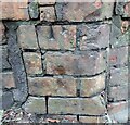
Hurworth, Low Hail Bridge
The benchmark is at the north end of the bridge and on the buttress on the east side. The cutmark is slightly damaged as the brickwork is deteriorating.
Image: © Mel Towler
Taken: 22 Jan 2023
0.12 miles
4
Hurworth, Low Hail Bridge
There is a benchmark at the north end of the bridge and on the buttress on the east side. The cutmark is slightly damaged as the brickwork is deteriorating.
Image: © Mel Towler
Taken: 22 Jan 2023
0.12 miles
5
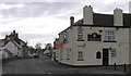
The Otter And Fish : Hurworth
The Emerson Arms is the tall building on the left.
Image: © Hugh Mortimer
Taken: 27 Apr 2006
0.12 miles
6
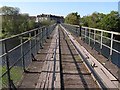
Low Hail Bridge : Hurworth
Built between 1877-1879 near an old ford. It was financed jointly by the Durham villagers and Lord Rokeby, who owned the land on the Yorkshire side. It was a joint project because it solved two different problems; Lord Rokeby was looking for fertiliser for his fields; the Hurworth residents were looking for some way to get rid of their sewage. Low Hail Bridge brought the sewage to the fields.
Image: © Hugh Mortimer
Taken: 23 Apr 2006
0.13 miles
7
Low Hail Bridge
This bridge carries the bridleway from Low Hail Farm over the Tees to Hurworth. The deck is in very poor condition and a notice at the north end states that the bridge is closed. Fortunately the gate was open, otherwise it would have been a long detour.
Image: © Oliver Dixon
Taken: 12 May 2009
0.13 miles
8
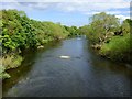
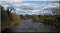
River Tees, Hurworth
Looking east from Low Hail Bridge, where, unlike other contributors to Geograph, I was disappointed to find the high gate on its northern side to be padlocked. Having approached from the south a lengthy detour was necessitated.
Image: © Andrew Smith
Taken: 24 May 2019
0.13 miles
9
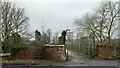
Low Hail Bridge
The bridge was constructed around 1870 to carry sewage pipes across the river, providing sewage from Hurworth for use as fertiliser on the Yorkshire side. A public bridleway runs right up to the bridge on the Yorkshire bank, though the bridge itself is privately owned. On the day this image was taken the gates were closed and padlocked shut preventing access. I can find no information as to why the bridge is/was closed or if this is a regular occurrence, but anyone approaching from the Yorkshire side would be faced with a detour of several miles upon finding the bridge closed.
Image: © David Robinson
Taken: 23 Oct 2021
0.14 miles
10
River Tees from Low Hail Bridge
The Tees flows east in this view. A notice affixed to Low Hail Bridge informs/warns that "There is no right of way over this bridge and unauthorised persons using it are trespassing and do so entirely at their own risk". Having said that there seems to be no attempt to prevent use of the bridge which carries the access road to Low Hail Farm. The status of access over bridge is clearly in some doubt as a public bridleway reaches its south end and both OS. Landranger and Explorer maps are clear in showing the right of way extending across it.
Image: © Trevor Littlewood
Taken: 27 Mar 2010
0.14 miles