IMAGES TAKEN NEAR TO
East Close, DARLINGTON, DL2 1SG
Introduction
This page details the photographs taken nearby to East Close, DL2 1SG by members of the Geograph project.
The Geograph project started in 2005 with the aim of publishing, organising and preserving representative images for every square kilometre of Great Britain, Ireland and the Isle of Man.

There are currently over 7.5m images from over14,400 individuals and you can help contribute to the project by visiting https://www.geograph.org.uk
Image Map
Images are licensed for reuse under creativecommons.org/licenses/by-sa/2.0
Notes
- Clicking on the map will re-center to the selected point.
- The higher the marker number, the further away the image location is from the centre of the postcode.
Image Listing (14 Images Found)
Images are licensed for reuse under creativecommons.org/licenses/by-sa/2.0
Image
Details
Distance
1
Sadberge
A village now bypassed by the A66. Looking east towards Stockton.
Image: © Mick Garratt
Taken: 5 Nov 2005
0.08 miles
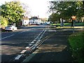
2
Sadberge village green
Three Tuns public house in the distance (just to the left of the tree). The large stone at the left hand edge of the picture commemorates Queen Victoria's Jubilee
Image: © Oliver Dixon
Taken: 9 May 2006
0.08 miles
3
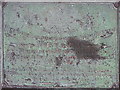
Commemorative Plaque : Sadberge Green.
Victoria's Jubilee 1887. On large glacial boulder
Image: © Hugh Mortimer
Taken: 27 Jun 2006
0.08 miles
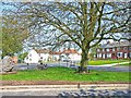
4
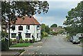
Sadberge village and pub
The village is now something of a backwater off the A66 which by-passes to the south. The road through the village was once the A67, the original designation of the main Darlington to Stockton road. On the left is 'The Tuns at Sadberge' pub, which appears to have had a makeover since it was photographed by J Thomas a few years ago.
Image: © Gordon Hatton
Taken: 11 Sep 2023
0.09 miles

8
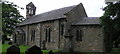
St. Andrew's : Sadberge
A Norman church on this site was replaced in the 1830's by the present day church.
Image: © Hugh Mortimer
Taken: 27 Jun 2006
0.12 miles
9
Hill House Lane heading north
Old Roman Road.
Image: © JThomas
Taken: 5 Jan 2013
0.13 miles