IMAGES TAKEN NEAR TO
Hurworth Moor, DARLINGTON, DL2 1QQ
Introduction
This page details the photographs taken nearby to DL2 1QQ by members of the Geograph project.
The Geograph project started in 2005 with the aim of publishing, organising and preserving representative images for every square kilometre of Great Britain, Ireland and the Isle of Man.

There are currently over 7.5m images from over14,400 individuals and you can help contribute to the project by visiting https://www.geograph.org.uk
Image Map
Images are licensed for reuse under creativecommons.org/licenses/by-sa/2.0
Notes
- Clicking on the map will re-center to the selected point.
- The higher the marker number, the further away the image location is from the centre of the postcode.
Image Listing (2 Images Found)
Images are licensed for reuse under creativecommons.org/licenses/by-sa/2.0
Image
Details
Distance
1
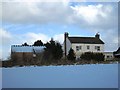
Low Maidendale Farm
This photograph shows a view of Low Maidendale Farm after a fall of snow in early January. The picture was taken looking in a northerly direction towards Maidendale Gill.
Image: © Philip Barker
Taken: 10 Jan 2010
0.04 miles
2
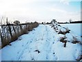
Footpath to Neasham Springs
This photograph shows a snow-laden path going from Low Maidendale Farm to Neasham Springs. The picture was taken looking in a westerly direction from Low Maidendale Farm.
Image: © Philip Barker
Taken: 10 Jan 2010
0.11 miles