IMAGES TAKEN NEAR TO
Church Lane, DARLINGTON, DL2 1DF
Introduction
This page details the photographs taken nearby to Church Lane, DL2 1DF by members of the Geograph project.
The Geograph project started in 2005 with the aim of publishing, organising and preserving representative images for every square kilometre of Great Britain, Ireland and the Isle of Man.

There are currently over 7.5m images from over14,400 individuals and you can help contribute to the project by visiting https://www.geograph.org.uk
Image Map
Images are licensed for reuse under creativecommons.org/licenses/by-sa/2.0
Notes
- Clicking on the map will re-center to the selected point.
- The higher the marker number, the further away the image location is from the centre of the postcode.
Image Listing (11 Images Found)
Images are licensed for reuse under creativecommons.org/licenses/by-sa/2.0
Image
Details
Distance
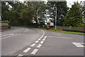
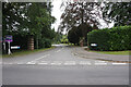
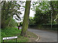
1
Castle Close, Middleton St George
A Conservative area
Image: © Alex McGregor
Taken: 27 Apr 2010
0.08 miles
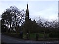
3

St. Laurence Church
The parish church of Middleton St.George.
Image: © Mick Garratt
Taken: 5 Nov 2005
0.17 miles
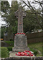
6
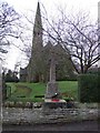
War Memorial and church, Middleton St.George
Image: © JThomas
Taken: 5 Jan 2013
0.19 miles
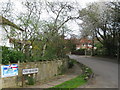
7

Footbridge and stile on footpath south of Middleton St George
Image: © Peter Robinson
Taken: 30 May 2012
0.19 miles