IMAGES TAKEN NEAR TO
Middleton St. George, DARLINGTON, DL2 1AX
Introduction
This page details the photographs taken nearby to DL2 1AX by members of the Geograph project.
The Geograph project started in 2005 with the aim of publishing, organising and preserving representative images for every square kilometre of Great Britain, Ireland and the Isle of Man.

There are currently over 7.5m images from over14,400 individuals and you can help contribute to the project by visiting https://www.geograph.org.uk
Image Map
Images are licensed for reuse under creativecommons.org/licenses/by-sa/2.0
Notes
- Clicking on the map will re-center to the selected point.
- The higher the marker number, the further away the image location is from the centre of the postcode.
Image Listing (20 Images Found)
Images are licensed for reuse under creativecommons.org/licenses/by-sa/2.0
Image
Details
Distance
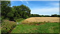
1
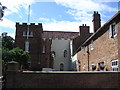
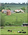
Low Middleton Hall
The original Hall was built in 1721, the tower added in the 19th century.
Image: © Hugh Mortimer
Taken: 3 Sep 2006
0.04 miles
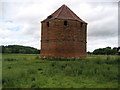
3
Octagonal dovecote by Low Middleton Farm, Middleton One Row
Image: © Colin Park
Taken: 9 Aug 2022
0.11 miles
4

Octagonal dovecote by Low Middleton Farm, Middleton One Row
Image: © Colin Park
Taken: 9 Aug 2022
0.11 miles
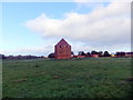
6
River and Dovecot
Looking across the River Tees to the 18th century octagonal dovecot at Low Middleton Hall, which is off picture to the left.
Image: © Gordon Hatton
Taken: 7 Jun 2009
0.12 miles
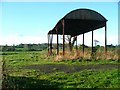
9
Dovecote at Low Middleton Farm
Partially dilapidated octagonal dovecote passed by on the Teesdale Way at Low Middleton Farm.
Image: © Chris Heaton
Taken: 7 Jul 2010
0.13 miles
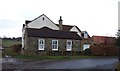
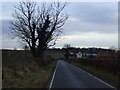
10
On the Teesdale Way SE of Middleton One Row
Image: © Colin Park
Taken: 9 Aug 2022
0.14 miles