IMAGES TAKEN NEAR TO
Rosebay Court, FERRYHILL, DL17 9JU
Introduction
This page details the photographs taken nearby to Rosebay Court, DL17 9JU by members of the Geograph project.
The Geograph project started in 2005 with the aim of publishing, organising and preserving representative images for every square kilometre of Great Britain, Ireland and the Isle of Man.

There are currently over 7.5m images from over14,400 individuals and you can help contribute to the project by visiting https://www.geograph.org.uk
Image Map
Images are licensed for reuse under creativecommons.org/licenses/by-sa/2.0
Notes
- Clicking on the map will re-center to the selected point.
- The higher the marker number, the further away the image location is from the centre of the postcode.
Image Listing (12 Images Found)
Images are licensed for reuse under creativecommons.org/licenses/by-sa/2.0
Image
Details
Distance
1
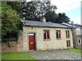
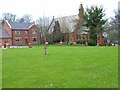
Cottage on the green at Cornforth
The green is the old part of Cornforth village and dates back to the Middle Ages. However, most of the existing properties are Victorian, as is this cottage, dated 1851 on the lintel above the door.
Image: © Robert Graham
Taken: 18 Sep 2013
0.06 miles
2
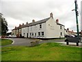
The Square and Compass, Cornforth
This pub is on the green in the centre of the village. This is the original part of the village and doesn't seem to have changed since the 1863 Ordnance Survey map. The village dates back to the early middle ages, but the present houses would seem to be 19th or possibly 18th century.
Image: © Robert Graham
Taken: 18 Sep 2013
0.13 miles
3
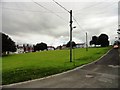
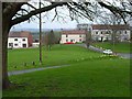
Looking south over the green, Cornforth
This is the old part of Cornforth village, and very nice it looks. The green dates back to the early middle ages, with a first mention in 1180. The present buildings would seem to be no older than the 18th or 19th centuries however. The white building at the far side is the village pub, The Square and Compass.
Image: © Robert Graham
Taken: 18 Sep 2013
0.14 miles
6
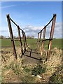
Rusted footbridge
An old footbridge over Coxhoe beck. A crossing for plant vehicles was created adjacent to the footbridge around 2015 during works replacing the electricity pylons, rendering the footbridge obsolete.
Image: © David Robinson
Taken: 2 Mar 2019
0.15 miles
7
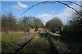
Disused Railway, Cornforth
The disused railway at Cornforth.
Image: © David Robinson
Taken: 3 Mar 2006
0.16 miles
8
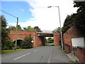
The railway bridge at Cornforth
On the appropriately named Bridge Street, on the north side of the village. View looking north. The railway is no longer used.
Image: © Robert Graham
Taken: 18 Sep 2013
0.17 miles
9
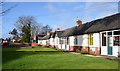
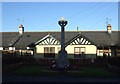
Miners' retirement homes
A pale yellow plaque at the centre of the run of bungalows and also at the centre of the image informs that the homes were provided by the Thrislington Colliery in 1925. The village war memorial (Cornforth) is at the left side of the image, largely shadowed.
Image: © Trevor Littlewood
Taken: 1 Feb 2020
0.18 miles