IMAGES TAKEN NEAR TO
Stobbcross Villas, FERRYHILL, DL17 9EZ
Introduction
This page details the photographs taken nearby to Stobbcross Villas, DL17 9EZ by members of the Geograph project.
The Geograph project started in 2005 with the aim of publishing, organising and preserving representative images for every square kilometre of Great Britain, Ireland and the Isle of Man.

There are currently over 7.5m images from over14,400 individuals and you can help contribute to the project by visiting https://www.geograph.org.uk
Image Map
Images are licensed for reuse under creativecommons.org/licenses/by-sa/2.0
Notes
- Clicking on the map will re-center to the selected point.
- The higher the marker number, the further away the image location is from the centre of the postcode.
Image Listing (9 Images Found)
Images are licensed for reuse under creativecommons.org/licenses/by-sa/2.0
Image
Details
Distance
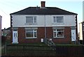
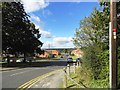
2
Laburnum Road, West Cornforth
This leads off Linden Road, the main road through the village on the eastern side. This side of the village is mainly of recent origin, 1950's or younger.
Image: © Robert Graham
Taken: 18 Sep 2013
0.14 miles
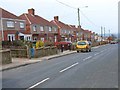
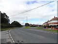
4
View north from Middleham Road, West Cornforth
Like many villages in this part of Durham, Cornforth was built on the East Durham limestone plateau which runs to the east of Durham City. This accounts for the fine views on a clear day like this one.
Image: © Robert Graham
Taken: 18 Sep 2013
0.17 miles
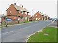
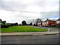
6
Junction of Linden Road with Garmonsway Road, West Cornforth
The village of West Cornforth dates from 1835, when a colliery was sunk to the west of old Cornforth village. This eastern part of the village is of course much more recent.
Image: © Robert Graham
Taken: 18 Sep 2013
0.23 miles
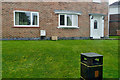
7
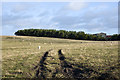
Belt of coniferous trees
The field with scattered sheep rises to the trees beyond which are industrial or farm buildings which on OS maps are described collectively as 'factory'.
Image: © Trevor Littlewood
Taken: 1 Feb 2020
0.23 miles