IMAGES TAKEN NEAR TO
Roast Calf Lane, FERRYHILL, DL17 9AT
Introduction
This page details the photographs taken nearby to Roast Calf Lane, DL17 9AT by members of the Geograph project.
The Geograph project started in 2005 with the aim of publishing, organising and preserving representative images for every square kilometre of Great Britain, Ireland and the Isle of Man.

There are currently over 7.5m images from over14,400 individuals and you can help contribute to the project by visiting https://www.geograph.org.uk
Image Map
Images are licensed for reuse under creativecommons.org/licenses/by-sa/2.0
Notes
- Clicking on the map will re-center to the selected point.
- The higher the marker number, the further away the image location is from the centre of the postcode.
Image Listing (16 Images Found)
Images are licensed for reuse under creativecommons.org/licenses/by-sa/2.0
Image
Details
Distance
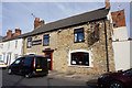
4
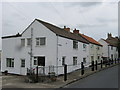
Ye Olde Fleece Inn Bishop Middleham County Durham
Image: © Peter Robinson
Taken: 18 Nov 2010
0.10 miles
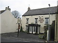
5
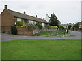
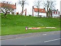
Junction on Roast Calf Lane and Perm Terrace in Bishop Middleham
Image: © Peter Robinson
Taken: 28 Jun 2011
0.10 miles
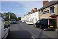
6
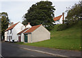
Eastern end of High Street in Bishop Middleham
Image: © Peter Robinson
Taken: 28 Jun 2011
0.10 miles
10
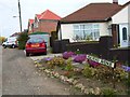
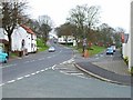
High Road Avenue, Bishop Middleham
A short unadopted road, off High Road
Image: © Oliver Dixon
Taken: 20 Apr 2006
0.16 miles