IMAGES TAKEN NEAR TO
Barrington Terrace, FERRYHILL, DL17 8NW
Introduction
This page details the photographs taken nearby to Barrington Terrace, DL17 8NW by members of the Geograph project.
The Geograph project started in 2005 with the aim of publishing, organising and preserving representative images for every square kilometre of Great Britain, Ireland and the Isle of Man.

There are currently over 7.5m images from over14,400 individuals and you can help contribute to the project by visiting https://www.geograph.org.uk
Image Map
Images are licensed for reuse under creativecommons.org/licenses/by-sa/2.0
Notes
- Clicking on the map will re-center to the selected point.
- The higher the marker number, the further away the image location is from the centre of the postcode.
Image Listing (12 Images Found)
Images are licensed for reuse under creativecommons.org/licenses/by-sa/2.0
Image
Details
Distance
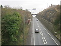
1
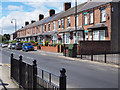
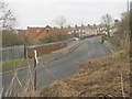
Terraced housing on Merrington Road
The terrace is on the north side of Merrington Road, the B6287, just west of the town centre of Ferryhill.
Image: © Trevor Littlewood
Taken: 15 Aug 2017
0.06 miles
2
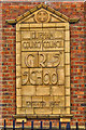
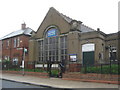
Ferryhill Girls' School
Now under the name of the Dean Bank Primary and Nursery School.
Image: © Mick Garratt
Taken: 6 Sep 2017
0.08 miles
4
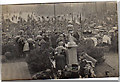
Ferryhill Market Square 1945
Celebrating the end of the second world war
Image: © Colin Coates
Taken: Unknown
0.12 miles
5
Ferryhill Baptist Church
In St Cuthberts Terrace Dean Bank
Image: © Peter Robinson
Taken: 20 Aug 2010
0.12 miles
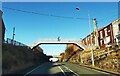
8
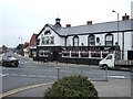
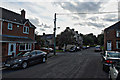
The Black Bull, Ferryhill
At the junction for Kirk Merrington.
Image: © Stanley Howe
Taken: 6 Jun 2007
0.19 miles
10
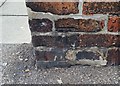
Ordnance Survey Cut Mark
This OS cut mark can be found on No29 Darlington Road. It marks a point 152.967m above mean sea level.
Image: © Adrian Dust
Taken: 15 Sep 2018
0.20 miles