IMAGES TAKEN NEAR TO
Lime Road, FERRYHILL, DL17 8DN
Introduction
This page details the photographs taken nearby to Lime Road, DL17 8DN by members of the Geograph project.
The Geograph project started in 2005 with the aim of publishing, organising and preserving representative images for every square kilometre of Great Britain, Ireland and the Isle of Man.

There are currently over 7.5m images from over14,400 individuals and you can help contribute to the project by visiting https://www.geograph.org.uk
Image Map
Images are licensed for reuse under creativecommons.org/licenses/by-sa/2.0
Notes
- Clicking on the map will re-center to the selected point.
- The higher the marker number, the further away the image location is from the centre of the postcode.
Image Listing (29 Images Found)
Images are licensed for reuse under creativecommons.org/licenses/by-sa/2.0
Image
Details
Distance
1
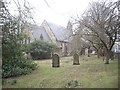
St Luke's Church, Ferryhill
Viewed from The Garth.
Image: © Stanley Howe
Taken: 9 Apr 2013
0.10 miles
2
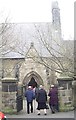
Entrance to St Luke's Church, Ferryhill
From Church Street.
Image: © Stanley Howe
Taken: 9 Apr 2013
0.10 miles
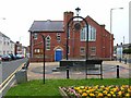
3
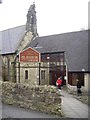
St Luke's Church Hall
Off Church Street, Ferryhill.
Image: © Stanley Howe
Taken: 9 Apr 2013
0.11 miles
4
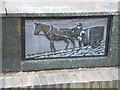
Detail of Beacon of Europe, Ferryhill
The Beacon of Europe was erected in 1992 to commemorate the single Market in Europe. This panel depicts the coal mining in the area. See http://www.pmsa.org.uk/pmsa-database/9929/
Image: © Oliver Dixon
Taken: 20 Apr 2006
0.14 miles
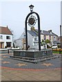
5
Beacon of Europe and Ferryhill Methodist Church
The Beacon of Europe was erected in 1992 to commemorate the Single Market in Europe. See http://www.pmsa.org.uk/pmsa-database/9929/
Image: © Oliver Dixon
Taken: 20 Apr 2006
0.14 miles
6
Beacon of Europe, Ferryhill
The Beacon of Europe was erected in 1992 to commemorate the single Market in Europe. See http://www.pmsa.org.uk/pmsa-database/9929/
Image: © Oliver Dixon
Taken: 20 Apr 2006
0.14 miles
7
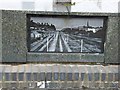
Detail of Beacon of Europe, Ferryhill
The Beacon of Europe was erected in 1992 to commemorate the single Market in Europe. This panel depicts the East Coast Main Line which passes through the town. See http://www.pmsa.org.uk/pmsa-database/9929/
Image: © Oliver Dixon
Taken: 20 Apr 2006
0.14 miles
9
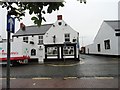
The White Horse, Ferryhill
Pub on Market Street, in the town centre.
Image: © Robert Graham
Taken: 27 Jun 2012
0.16 miles
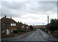
10
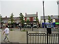
Market Street, Ferryhill
Looking south at the main street in Ferryhill.
Image: © Robert Graham
Taken: 27 Jun 2012
0.17 miles