IMAGES TAKEN NEAR TO
Bertha Street, FERRYHILL, DL17 8AZ
Introduction
This page details the photographs taken nearby to Bertha Street, DL17 8AZ by members of the Geograph project.
The Geograph project started in 2005 with the aim of publishing, organising and preserving representative images for every square kilometre of Great Britain, Ireland and the Isle of Man.

There are currently over 7.5m images from over14,400 individuals and you can help contribute to the project by visiting https://www.geograph.org.uk
Image Map
Images are licensed for reuse under creativecommons.org/licenses/by-sa/2.0
Notes
- Clicking on the map will re-center to the selected point.
- The higher the marker number, the further away the image location is from the centre of the postcode.
Image Listing (16 Images Found)
Images are licensed for reuse under creativecommons.org/licenses/by-sa/2.0
Image
Details
Distance
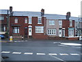
1

Looking down Broom Road, Ferryhill
View south down this long road which leads SE out of the town centre.
Image: © Robert Graham
Taken: 27 Jun 2012
0.05 miles
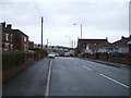
3

Road junction, Ferryhill
Junction of Dean Road with Broom Road on the east side of the town.
Image: © Robert Graham
Taken: 27 Jun 2012
0.08 miles
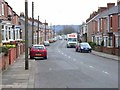
7
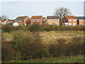
New Housing at Ferryhill
New houses being built at Ferryhill expand out into the open land at the southern end of the village.
Image: © Philip Barker
Taken: 8 Nov 2009
0.14 miles
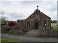
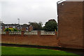
10
Former Church, now occupied by a local funeral director.
Image: © Bill Henderson
Taken: 26 Apr 2007
0.15 miles