IMAGES TAKEN NEAR TO
Avenue Three, FERRYHILL, DL17 0PB
Introduction
This page details the photographs taken nearby to Avenue Three, DL17 0PB by members of the Geograph project.
The Geograph project started in 2005 with the aim of publishing, organising and preserving representative images for every square kilometre of Great Britain, Ireland and the Isle of Man.

There are currently over 7.5m images from over14,400 individuals and you can help contribute to the project by visiting https://www.geograph.org.uk
Image Map
Images are licensed for reuse under creativecommons.org/licenses/by-sa/2.0
Notes
- Clicking on the map will re-center to the selected point.
- The higher the marker number, the further away the image location is from the centre of the postcode.
Image Listing (6 Images Found)
Images are licensed for reuse under creativecommons.org/licenses/by-sa/2.0
Image
Details
Distance
1
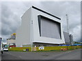
Chilton Biomass Energy Centre County Durham
Image: © Peter Robinson
Taken: 27 May 2011
0.15 miles
2
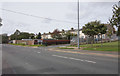
Dene Bridge Row Chilton County Durham
On the Chilton to Kirk Merrington Road
Image: © Peter Robinson
Taken: 17 Feb 2010
0.19 miles
3
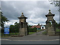
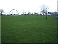
Entrance to Chilton Miners Welfare Recreation Ground
Image: © Peter Robinson
Taken: 27 May 2011
0.21 miles