IMAGES TAKEN NEAR TO
Nable Hill Close, FERRYHILL, DL17 0GY
Introduction
This page details the photographs taken nearby to Nable Hill Close, DL17 0GY by members of the Geograph project.
The Geograph project started in 2005 with the aim of publishing, organising and preserving representative images for every square kilometre of Great Britain, Ireland and the Isle of Man.

There are currently over 7.5m images from over14,400 individuals and you can help contribute to the project by visiting https://www.geograph.org.uk
Image Map
Images are licensed for reuse under creativecommons.org/licenses/by-sa/2.0
Notes
- Clicking on the map will re-center to the selected point.
- The higher the marker number, the further away the image location is from the centre of the postcode.
Image Listing (10 Images Found)
Images are licensed for reuse under creativecommons.org/licenses/by-sa/2.0
Image
Details
Distance

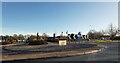
3
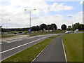
Rushyford Roundabout
Looking northwards, along the A167 towards its junction with the A689 at Rushyford.
Image: © David Dixon
Taken: 20 Jun 2011
0.17 miles
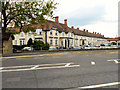
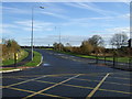
6

Eden Arms Hotel : Rushyford
A former coaching inn at the junction of the A167(T) and A689.
Image: © Hugh Mortimer
Taken: 16 Jun 2006
0.21 miles
7
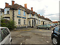
The Eden Arms Hotel, Rushyford
A former coaching house.
Image: © David Dixon
Taken: 20 Jun 2011
0.21 miles