IMAGES TAKEN NEAR TO
Rudds Hill, FERRYHILL, DL17 0AQ
Introduction
This page details the photographs taken nearby to Rudds Hill, DL17 0AQ by members of the Geograph project.
The Geograph project started in 2005 with the aim of publishing, organising and preserving representative images for every square kilometre of Great Britain, Ireland and the Isle of Man.

There are currently over 7.5m images from over14,400 individuals and you can help contribute to the project by visiting https://www.geograph.org.uk
Image Map
Images are licensed for reuse under creativecommons.org/licenses/by-sa/2.0
Notes
- Clicking on the map will re-center to the selected point.
- The higher the marker number, the further away the image location is from the centre of the postcode.
Image Listing (22 Images Found)
Images are licensed for reuse under creativecommons.org/licenses/by-sa/2.0
Image
Details
Distance
1
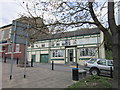
The Commercial Hotel, Ferryhill
A free house selling some Sam Smith's products.
Image: © Ian S
Taken: 7 May 2012
0.03 miles
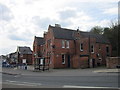
2
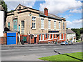
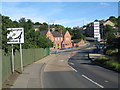
Buildings on north side of High Street, Ferryhill Station
The locations Ferryhill and Ferryhill Station are continuous built up areas with the former being much the larger. High Street branches from the foreground road having on its north side the premises of The Mainsforth and District Community Association and below them, The Commercial Hotel.
Image: © Trevor Littlewood
Taken: 15 Aug 2017
0.03 miles
3
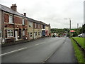
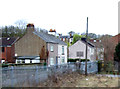
Bottom end of Broom Road, Ferryhill
Looking east down to the bottom of the bank.
Image: © Robert Graham
Taken: 27 Jun 2012
0.05 miles
4
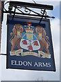
The Eldon Arms, Ferryhill
The only Sam Smiths public house in Ferryhill.
Image: © Ian S
Taken: 7 May 2012
0.05 miles
5
The Eldon Arms, Ferryhill
The only Sam Smiths public house in Ferryhill.
Image: © Ian S
Taken: 7 May 2012
0.06 miles
6
The Eldon Arms, Ferryhill
The only Sam Smiths public house in Ferryhill.
Image: © Ian S
Taken: 7 May 2012
0.06 miles
10
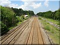
Ferryhill railway station (site), County Durham
Opened in 1835 by the Clarence Railway from Stockton to Coxhoe, the York Newcastle and Berwick Railway also opened through here in 1844. Both later became part of the North Eastern Railway.
View north towards Croxdale and Newcastle, also formerly Coxhoe. The original station(s) was/were to the left of the current lines, near the still extant goods shed. A new station was built in the centre of the image in 1876, which continued behind the camera position. It closed to passengers in 1967.
For more information, see http://www.disused-stations.org.uk/f/ferryhill/index.shtml
Image: © Nigel Thompson
Taken: 29 May 2021
0.09 miles