IMAGES TAKEN NEAR TO
Ivy Close, SPENNYMOOR, DL16 7UJ
Introduction
This page details the photographs taken nearby to Ivy Close, DL16 7UJ by members of the Geograph project.
The Geograph project started in 2005 with the aim of publishing, organising and preserving representative images for every square kilometre of Great Britain, Ireland and the Isle of Man.

There are currently over 7.5m images from over14,400 individuals and you can help contribute to the project by visiting https://www.geograph.org.uk
Image Map
Images are licensed for reuse under creativecommons.org/licenses/by-sa/2.0
Notes
- Clicking on the map will re-center to the selected point.
- The higher the marker number, the further away the image location is from the centre of the postcode.
Image Listing (12 Images Found)
Images are licensed for reuse under creativecommons.org/licenses/by-sa/2.0
Image
Details
Distance
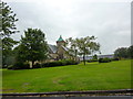
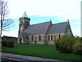
4
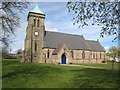
St Paul's Church, Spennymoor
Founded in 1858, the parish church of Spennymoor was destroyed by fire in the 1950s and extensively rebuilt. http://www.stpaulsspennymoor.co.uk/news/content.asp?NewsID=5
Image: © Oliver Dixon
Taken: 16 Apr 2007
0.20 miles
10
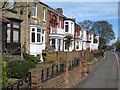
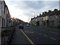
Whitworth, Spennymoor
A fine terrace of Edwardian houses.
Image: © Oliver Dixon
Taken: 16 Apr 2007
0.21 miles