IMAGES TAKEN NEAR TO
Nelson Walk, SPENNYMOOR, DL16 7RH
Introduction
This page details the photographs taken nearby to Nelson Walk, DL16 7RH by members of the Geograph project.
The Geograph project started in 2005 with the aim of publishing, organising and preserving representative images for every square kilometre of Great Britain, Ireland and the Isle of Man.

There are currently over 7.5m images from over14,400 individuals and you can help contribute to the project by visiting https://www.geograph.org.uk
Image Map
Images are licensed for reuse under creativecommons.org/licenses/by-sa/2.0
Notes
- Clicking on the map will re-center to the selected point.
- The higher the marker number, the further away the image location is from the centre of the postcode.
Image Listing (11 Images Found)
Images are licensed for reuse under creativecommons.org/licenses/by-sa/2.0
Image
Details
Distance
1
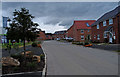
Burton Woods at Whitworth Park
New build development near Spennyworth.
Image: © wfmillar
Taken: 2 Aug 2016
0.04 miles
2
Burton Woods at Whitworth Park
New build development near Spennymoor.
Image: © wfmillar
Taken: 2 Aug 2016
0.06 miles
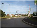
3
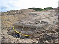
Building site, Spennymoor
Seen from a footpath running along the north side of Spennymoor, this building site in the early stages of development offers a complete contrast to the rustic view in the opposite direction Image
Image: © Oliver Dixon
Taken: 16 Apr 2007
0.09 miles
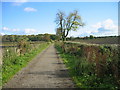
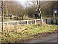
4

Path at west side of Spennymoor
The path setting is rural at present but is being encroached upon by new housing development from the south, left of the line of view.
Image: © Trevor Littlewood
Taken: 14 Jul 2012
0.10 miles
6
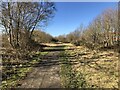
Footpath, Spennymoor
Though not part of the Auckland Way, the footpath uses the same former railway alignment, becoming the Auckland Way at the edge of the town and continuing to Bishop Auckland.
Image: © David Robinson
Taken: 1 Mar 2022
0.14 miles
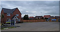
7
Burton Woods housing estate, Spennymoor (2013)
Under construction; with show houses for inspection.
Image: © Stanley Howe
Taken: 21 Sep 2013
0.15 miles
8
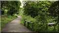
Auckland Walk west of Spennymoor
The Auckland Walk uses an old railway route to connect the towns of Spennymoor and Bishop Auckland. The view here was recorded close to Spennymoor on the north side of the grounds of The Meadows School. A pipeline can be seen passing under the path.
Image: © Trevor Littlewood
Taken: 14 Jul 2012
0.16 miles
9
Crossing on the Auckland Way, Whitworth Road near Spennymoor
On Whitworth Road. The Clarence Railway, opened 1837, ran between Spennymoor and Bishop Auckland. The trackbed has now been converted into the Auckland Way http://www.cobr.co.uk/e-cobr_information/cycling_initiatives/sections/rail_trails/auckland_way/text.shtml , an attractive path for walkers and cyclists.
Image: © Oliver Dixon
Taken: 18 Feb 2007
0.21 miles
10
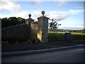
Entry to Burton Woods at Whitworth Park
A major housing development on the outskirts of Spennymoor.
Image: © Stanley Howe
Taken: 21 Sep 2013
0.23 miles