IMAGES TAKEN NEAR TO
Green Rise, SPENNYMOOR, DL16 7PL
Introduction
This page details the photographs taken nearby to Green Rise, DL16 7PL by members of the Geograph project.
The Geograph project started in 2005 with the aim of publishing, organising and preserving representative images for every square kilometre of Great Britain, Ireland and the Isle of Man.

There are currently over 7.5m images from over14,400 individuals and you can help contribute to the project by visiting https://www.geograph.org.uk
Image Map
Images are licensed for reuse under creativecommons.org/licenses/by-sa/2.0
Notes
- Clicking on the map will re-center to the selected point.
- The higher the marker number, the further away the image location is from the centre of the postcode.
Image Listing (18 Images Found)
Images are licensed for reuse under creativecommons.org/licenses/by-sa/2.0
Image
Details
Distance
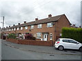
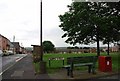
1
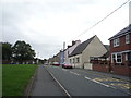
High Street, Byers Green
Looking north west.
Image: © JThomas
Taken: 27 Aug 2018
0.05 miles
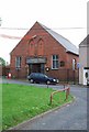
2
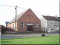
Methodist Church at Byers Green
This photograph shows a view of the Methodist Church in Byers Green. The picture was taken from on the village green (near Lodge Street) looking in a south-westerly direction towards Newfield.
Image: © Philip Barker
Taken: 27 Jan 2010
0.05 miles
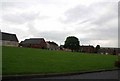
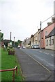
3
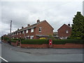
Houses on Wear View, Byers Green
Showing position of Postbox No. DL16 131.
See Image] for postbox.
Image: © JThomas
Taken: 27 Aug 2018
0.06 miles
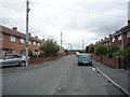
4
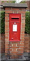
Elizabeth II postbox on Wear View, Byers Green
Postbox No. DL16 131.
See Image] for context.
Image: © JThomas
Taken: 27 Aug 2018
0.06 miles