IMAGES TAKEN NEAR TO
Hallgarth, SPENNYMOOR, DL16 7HR
Introduction
This page details the photographs taken nearby to Hallgarth, DL16 7HR by members of the Geograph project.
The Geograph project started in 2005 with the aim of publishing, organising and preserving representative images for every square kilometre of Great Britain, Ireland and the Isle of Man.

There are currently over 7.5m images from over14,400 individuals and you can help contribute to the project by visiting https://www.geograph.org.uk
Image Map
Images are licensed for reuse under creativecommons.org/licenses/by-sa/2.0
Notes
- Clicking on the map will re-center to the selected point.
- The higher the marker number, the further away the image location is from the centre of the postcode.
Image Listing (23 Images Found)
Images are licensed for reuse under creativecommons.org/licenses/by-sa/2.0
Image
Details
Distance
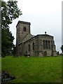
1
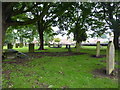
Kirk Merrington Parish Church, St John the Evangelist, Graveyard
Image: © Alexander P Kapp
Taken: 26 Aug 2011
0.07 miles
2
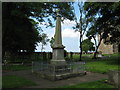
Kirk Merrington War Memorial
In this County Durham village situated in the Parish Churchyard
Image: © Peter Robinson
Taken: 21 Jun 2009
0.08 miles
3
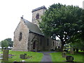
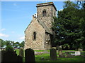
Kirk Merrington Parish Church, St John the Evangelist
Image: © Alexander P Kapp
Taken: 26 Aug 2011
0.08 miles
4
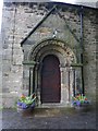
Kirk Merrington Parish Church, St John the Evangelist, Doorway
Image: © Alexander P Kapp
Taken: 26 Aug 2011
0.09 miles
5
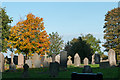
Gravestones with autumnal trees
Gravestones on the north side of the Church of St. John the Evangelist in the small village of Kirk Merrington.
Image: © Trevor Littlewood
Taken: 17 Oct 2015
0.09 miles
6
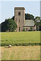
Kirk Merrington Parish Church
St John the Evangelist church, Kirk Merrington.
Image: © David Robinson
Taken: 19 Jul 2016
0.09 miles
7
Kirk Merrington Parish Church, St John the Evangelist
Image: © Alexander P Kapp
Taken: 26 Aug 2011
0.09 miles
8
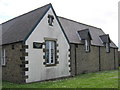
Community Centre
Centrally situated in Kirk Merrington County Durham
Image: © Peter Robinson
Taken: 21 Jun 2009
0.10 miles
9
Parish Church Kirk Merrington
Church of St John the Evangelist in this County Durham village
Image: © Peter Robinson
Taken: 21 Jun 2009
0.10 miles
10
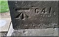
Ordnance Survey Cut Mark
This OS cut mark can be found on the south angle of St John's Church. It marks a point 195.420m above mean sea level.
Image: © Adrian Dust
Taken: 15 Sep 2018
0.10 miles