IMAGES TAKEN NEAR TO
Gervaulx Court, SPENNYMOOR, DL16 6YY
Introduction
This page details the photographs taken nearby to Gervaulx Court, DL16 6YY by members of the Geograph project.
The Geograph project started in 2005 with the aim of publishing, organising and preserving representative images for every square kilometre of Great Britain, Ireland and the Isle of Man.

There are currently over 7.5m images from over14,400 individuals and you can help contribute to the project by visiting https://www.geograph.org.uk
Image Map
Images are licensed for reuse under creativecommons.org/licenses/by-sa/2.0
Notes
- Clicking on the map will re-center to the selected point.
- The higher the marker number, the further away the image location is from the centre of the postcode.
Image Listing (3 Images Found)
Images are licensed for reuse under creativecommons.org/licenses/by-sa/2.0
Image
Details
Distance
1
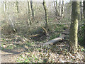
Footbridge over gully in woodland north of Spennymoor
Image: © Peter Robinson
Taken: 27 Mar 2011
0.13 miles
2
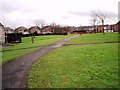
Public footpath through Tudhoe Grange
This photograph shows the route of the public footpath as it makes its way across the housing estate at Tudhoe Grange from Valley Burn to Black Plantation. This picture was taken on the section of the path that runs between Thirlmere and Glenmere (DL16) looking in a southerly direction towards Spennymoor.
Image: © Philip Barker
Taken: 27 Jan 2010
0.20 miles
3
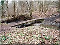
Bridge over Valley Burn
This photograph shows a view of the concrete bridge that crosses Valley Burn in the woods near Tudhoe Village. The flight of steps visible in the background lead up to the minor road near the sewage works. The picture was taken looking in a north-westerly direction towards the sewage works.
Image: © Philip Barker
Taken: 27 Jan 2010
0.22 miles