IMAGES TAKEN NEAR TO
Enterprise Way, SPENNYMOOR, DL16 6YP
Introduction
This page details the photographs taken nearby to Enterprise Way, DL16 6YP by members of the Geograph project.
The Geograph project started in 2005 with the aim of publishing, organising and preserving representative images for every square kilometre of Great Britain, Ireland and the Isle of Man.

There are currently over 7.5m images from over14,400 individuals and you can help contribute to the project by visiting https://www.geograph.org.uk
Image Map
Images are licensed for reuse under creativecommons.org/licenses/by-sa/2.0
Notes
- Clicking on the map will re-center to the selected point.
- The higher the marker number, the further away the image location is from the centre of the postcode.
Image Listing (6 Images Found)
Images are licensed for reuse under creativecommons.org/licenses/by-sa/2.0
Image
Details
Distance
1

Spennymoor fire station
Spennymoor fire station, Enterprise Way, Green Lane Industrial Estate, Spennymoor, County Durham
Image: © Kevin Hale
Taken: 3 Aug 2010
0.05 miles
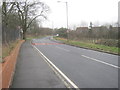
2
Spennymoor Community Fire Station in York Hill Road
Image: © Peter Robinson
Taken: 3 Feb 2013
0.07 miles
3

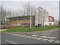
Education Development Centre, Enterprise Way, Spennymoor
This centre in the Green Lane Industrial Estate, run by the Durham Local Education Authority, looks in rather better shape than some of the authority's schools!
Image: © Oliver Dixon
Taken: 16 Apr 2007
0.09 miles
5
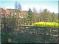
Back of Meadow Green, Tudhoe, Spennymoor
A tide of oilseed rape laps the back of Meadow Green on the eastern edge of Tudhoe.
Image: © Oliver Dixon
Taken: 16 Apr 2007
0.11 miles
6

Meadow Green, Tudhoe, Spennymoor
Part of the Coppice housing estate on the eastern edge of Tudhoe. Like many such developments, the name has been given to create a spurious image of rustic charm.
Image: © Oliver Dixon
Taken: 16 Apr 2007
0.12 miles