IMAGES TAKEN NEAR TO
Tudhoe Industrial Estate, SPENNYMOOR, DL16 6TL
Introduction
This page details the photographs taken nearby to Tudhoe Industrial Estate, DL16 6TL by members of the Geograph project.
The Geograph project started in 2005 with the aim of publishing, organising and preserving representative images for every square kilometre of Great Britain, Ireland and the Isle of Man.

There are currently over 7.5m images from over14,400 individuals and you can help contribute to the project by visiting https://www.geograph.org.uk
Image Map
Images are licensed for reuse under creativecommons.org/licenses/by-sa/2.0
Notes
- Clicking on the map will re-center to the selected point.
- The higher the marker number, the further away the image location is from the centre of the postcode.
Image Listing (8 Images Found)
Images are licensed for reuse under creativecommons.org/licenses/by-sa/2.0
Image
Details
Distance
4
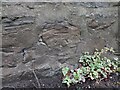
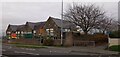
Tudhoe Colliery Primary School
The benchmark is cut into the south facing perimeter wall of the school grounds. A footpath runs alongside the wall.
Image: © Mel Towler
Taken: 13 Nov 2021
0.16 miles
5
Tudhoe Colliery Primary School
There is a benchmark cut into the south facing perimeter wall of the school grounds. A footpath runs alongside the wall and the benchmark is close to this large tree.
Image: © Mel Towler
Taken: 13 Nov 2021
0.16 miles
6
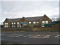
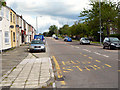
Tudhoe Colliery School on a Wet Day
This photograph shows Tudhoe Colliery School in County Durham. The picture was taken from the public footpath at NZ 266 369 and shows the B6288 road in the foreground. This road runs in a north-south direction between Tudhoe (to the south) and Croxdale (to the north). Another interesting picture of the school, taken from the public footpath at NZ 266 359, can be seen here Image
Image: © Philip Barker
Taken: 14 Nov 2009
0.17 miles
7

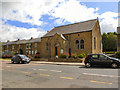
School at Tudhoe Colliery
The school lies at the northern end of the village on the B6288 road.
Image: © Philip Barker
Taken: 8 Nov 2009
0.18 miles
8

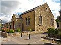
Tudhoe Colliery village
The colliery has long gone. The primary school can be seen to the left in the distance.
Image: © Oliver Dixon
Taken: 22 Sep 2006
0.18 miles