IMAGES TAKEN NEAR TO
Parkside, SPENNYMOOR, DL16 6RX
Introduction
This page details the photographs taken nearby to Parkside, DL16 6RX by members of the Geograph project.
The Geograph project started in 2005 with the aim of publishing, organising and preserving representative images for every square kilometre of Great Britain, Ireland and the Isle of Man.

There are currently over 7.5m images from over14,400 individuals and you can help contribute to the project by visiting https://www.geograph.org.uk
Image Map
Images are licensed for reuse under creativecommons.org/licenses/by-sa/2.0
Notes
- Clicking on the map will re-center to the selected point.
- The higher the marker number, the further away the image location is from the centre of the postcode.
Image Listing (7 Images Found)
Images are licensed for reuse under creativecommons.org/licenses/by-sa/2.0
Image
Details
Distance
1
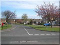
Parkside, Spennymoor
Typical of the modern housing estates which have sprung up on the north side of Spennymoor.
Image: © Oliver Dixon
Taken: 16 Apr 2007
0.06 miles
2
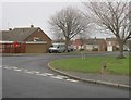
Entrance to Parkside off Carr Lane in Spennymoor
Image: © Peter Robinson
Taken: 3 Feb 2013
0.10 miles
4
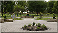
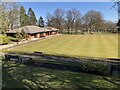
Spennymoor; sensory garden in Victoria Jubilee Park
Victoria Jubilee Park in Spennymoor is an immaculately presented area of lawns and gardens with plentiful trees, a tennis court, bowling greens and the usual children's play equipment. The view is over the sensory garden towards the bandstand which is mostly concealed.
Image: © Trevor Littlewood
Taken: 14 Jul 2012
0.15 miles
6
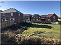
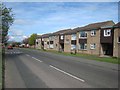
New Housing Development, Spennymoor
Extension of the Burton Woods development in Spennymoor.
Image: © David Robinson
Taken: 1 Mar 2022
0.19 miles
7
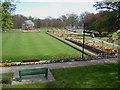
Jubilee Gardens, Spennymoor
A very attractive park, opened to commemorate Queen Victoria's Golden Jubilee.
Image: © Oliver Dixon
Taken: 16 Apr 2007
0.20 miles