IMAGES TAKEN NEAR TO
Watson Park, SPENNYMOOR, DL16 6NB
Introduction
This page details the photographs taken nearby to Watson Park, DL16 6NB by members of the Geograph project.
The Geograph project started in 2005 with the aim of publishing, organising and preserving representative images for every square kilometre of Great Britain, Ireland and the Isle of Man.

There are currently over 7.5m images from over14,400 individuals and you can help contribute to the project by visiting https://www.geograph.org.uk
Image Map
Images are licensed for reuse under creativecommons.org/licenses/by-sa/2.0
Notes
- Clicking on the map will re-center to the selected point.
- The higher the marker number, the further away the image location is from the centre of the postcode.
Image Listing (4 Images Found)
Images are licensed for reuse under creativecommons.org/licenses/by-sa/2.0
Image
Details
Distance
1
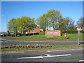
Green Lane Industrial Estate
Entrance to an industrial estate on the east side of Spennymoor.
Image: © Oliver Dixon
Taken: 16 Apr 2007
0.09 miles
2

Sedgefield Borough Council Offices, Spennymoor
The Borough of Sedgefield is a heterogenous mix of countryside, towns and villages spread across the south-eastern quarter of County Durham. The Borough is named after the ancient town of Sedgefield, but the largest town in the Borough is Newton Aycliffe and the Council Offices are located in a third town, Spennymoor. http://www.sedgefield.gov.uk The parliamentary constituency of Sedgefield, for which Tony Blair is MP, is partly coincident with the Borough.
Image: © Oliver Dixon
Taken: 16 Apr 2007
0.19 miles
3
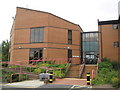
Conference Suite in Spennymoor
At Durham County Council offices
Image: © Peter Robinson
Taken: 16 Sep 2009
0.22 miles
4
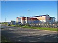
Education Development Centre, Enterprise Way, Spennymoor
This centre in the Green Lane Industrial Estate, run by the Durham Local Education Authority, looks in rather better shape than some of the authority's schools!
Image: © Oliver Dixon
Taken: 16 Apr 2007
0.23 miles