IMAGES TAKEN NEAR TO
Eden Crescent, DARLINGTON, DL1 5TW
Introduction
This page details the photographs taken nearby to Eden Crescent, DL1 5TW by members of the Geograph project.
The Geograph project started in 2005 with the aim of publishing, organising and preserving representative images for every square kilometre of Great Britain, Ireland and the Isle of Man.

There are currently over 7.5m images from over14,400 individuals and you can help contribute to the project by visiting https://www.geograph.org.uk
Image Map
Images are licensed for reuse under creativecommons.org/licenses/by-sa/2.0
Notes
- Clicking on the map will re-center to the selected point.
- The higher the marker number, the further away the image location is from the centre of the postcode.
Image Listing (10 Images Found)
Images are licensed for reuse under creativecommons.org/licenses/by-sa/2.0
Image
Details
Distance
2

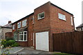
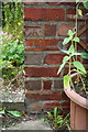
Benchmark on #129 Hammond Drive
Ordnance Survey cut mark benchmark described on the Bench Mark Database at http://www.bench-marks.org.uk/bm78672
Image: © Roger Templeman
Taken: 9 Sep 2016
0.13 miles
3
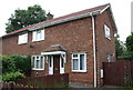
#129 Hammond Drive
There is an OS benchmark Image on the front of the house just left of the white downpipe
Image: © Roger Templeman
Taken: 9 Sep 2016
0.13 miles
5
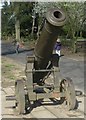
Sebastopol Cannon in South Park, Darlington
Crimean War relic. Abandoned by the Russians at Sebastopol in 1855 this one arrived in Darlington in 1857 and was placed in South Park as a War Memorial.
Image: © Stanley Howe
Taken: 7 Apr 2006
0.14 miles
6
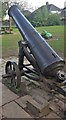
A captured cannon from the Crimean War
A permanent exhibit in South Park, Darlington.
Image: © Stanley Howe
Taken: 22 Apr 2017
0.14 miles
8
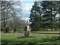
The Fowler Monument in South Park
This memorial plinth once (pre-1970) supported a 'steam plough', the invention in 1856 of a son-in-law of Joseph Pease named John Fowler. See http://www.leodis.net/display.aspx?resourceIdentifier=20021014_95162601 . The monument was originally on the Pierremont Estate, but was moved to South Park in 1870. Bank Top station clock can be seen in the distance, to the NE of the monument.
Image: © Stanley Howe
Taken: 7 Apr 2006
0.24 miles
9
Benchmark on #132 Parkside
Ordnance Survey cut mark benchmark described on the Bench Mark Database at http://www.bench-marks.org.uk/bm78673
Image: © Roger Templeman
Taken: 9 Sep 2016
0.25 miles
10
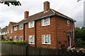
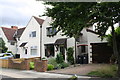
Semi-detached houses on Parkside, #132 nearest
There is an OS benchmark Image on the near corner, right hand face of #132, left of the small trellis
Image: © Roger Templeman
Taken: 9 Sep 2016
0.25 miles