IMAGES TAKEN NEAR TO
Bedford Street, DARLINGTON, DL1 5JU
Introduction
This page details the photographs taken nearby to Bedford Street, DL1 5JU by members of the Geograph project.
The Geograph project started in 2005 with the aim of publishing, organising and preserving representative images for every square kilometre of Great Britain, Ireland and the Isle of Man.

There are currently over 7.5m images from over14,400 individuals and you can help contribute to the project by visiting https://www.geograph.org.uk
Image Map
Images are licensed for reuse under creativecommons.org/licenses/by-sa/2.0
Notes
- Clicking on the map will re-center to the selected point.
- The higher the marker number, the further away the image location is from the centre of the postcode.
Image Listing (46 Images Found)
Images are licensed for reuse under creativecommons.org/licenses/by-sa/2.0
Image
Details
Distance
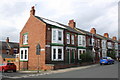
1
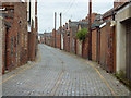
Back Alley
Alley between Victoria Embankment and Bedford Street
Image: © Richard Croft
Taken: 21 Sep 2011
0.01 miles
2
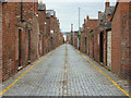
Back Alley
Alley between the rears of Victoria Embankment and Bedford Street
Image: © Richard Croft
Taken: 21 Sep 2011
0.06 miles
3
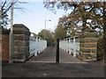
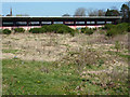
Polam Lane Bridge over the River Skerne in Darlington
See http://britishlistedbuildings.co.uk/en-496054-polam-lane-bridge-darlington
Image: © Peter Robinson
Taken: 12 Nov 2011
0.08 miles
4
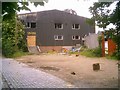
The Quaker Centre, Polam Lane, Darlington
Taken only weeks after closure, the Quaker Sports Centre had already been badly vandalised.
Image: © mark harrington
Taken: 13 Jun 2005
0.09 miles
5

Feethams Football Ground, Darlington
Taken two years after the last game, the football ground is insecure and derelict. It is hoped it will be redeveloped for housing.
Image: © mark harrington
Taken: 13 Sep 2005
0.09 miles
6
Feethams
Home to Darlington FC for 120 years, the 'tin shed' north stand is all that remains with the pitch overgrown since the last game was played here on 3rd May 2003.
Image: © Richard Croft
Taken: 30 Mar 2012
0.10 miles
7
Junction of Clifton Road and Milner Road
There is an OS benchmark Image on the corner of the nearest house at its junction with its front side boundary wall
Image: © Roger Templeman
Taken: 9 Sep 2016
0.12 miles
8
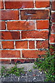
Benchmark on #106 Clifton Road
Ordnance Survey cut mark benchmark described on the Bench Mark Database at http://www.bench-marks.org.uk/bm78677
Image: © Roger Templeman
Taken: 9 Sep 2016
0.12 miles
9

Sunrise over a snowy South Park
One of only two mornings last winter when snow had fallen
Image: © mark harrington
Taken: 3 Mar 2005
0.12 miles
10
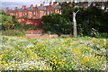
Manhole surrounds behind flowers in South Park
Image: © Roger Templeman
Taken: 9 Sep 2016
0.13 miles