IMAGES TAKEN NEAR TO
Chatsworth Terrace, DARLINGTON, DL1 5DH
Introduction
This page details the photographs taken nearby to Chatsworth Terrace, DL1 5DH by members of the Geograph project.
The Geograph project started in 2005 with the aim of publishing, organising and preserving representative images for every square kilometre of Great Britain, Ireland and the Isle of Man.

There are currently over 7.5m images from over14,400 individuals and you can help contribute to the project by visiting https://www.geograph.org.uk
Image Map
Images are licensed for reuse under creativecommons.org/licenses/by-sa/2.0
Notes
- Clicking on the map will re-center to the selected point.
- The higher the marker number, the further away the image location is from the centre of the postcode.
Image Listing (169 Images Found)
Images are licensed for reuse under creativecommons.org/licenses/by-sa/2.0
Image
Details
Distance
1
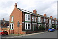
Junction of Clifton Road and Milner Road
There is an OS benchmark Image on the corner of the nearest house at its junction with its front side boundary wall
Image: © Roger Templeman
Taken: 9 Sep 2016
0.03 miles
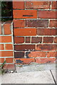
2
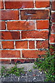
Benchmark on #106 Clifton Road
Ordnance Survey cut mark benchmark described on the Bench Mark Database at http://www.bench-marks.org.uk/bm78677
Image: © Roger Templeman
Taken: 9 Sep 2016
0.03 miles
3
Benchmark on #52B Clifton Road
Ordnance Survey cut mark benchmark described on the Bench Mark Database at http://www.bench-marks.org.uk/bm78678
Image: © Roger Templeman
Taken: 9 Sep 2016
0.09 miles
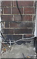
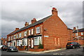
4
Nos. 48, 50, and 52 Clifton Road
There is an OS benchmark Image behind the wheelie bin at the junction of Nos. 50 and 52.
Image: © Roger Templeman
Taken: 9 Sep 2016
0.09 miles
5
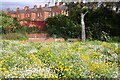
Manhole surrounds behind flowers in South Park
Image: © Roger Templeman
Taken: 9 Sep 2016
0.09 miles
6
Junction of Clifton Road and Henderson Street
There is an OS benchmark Image on the bricks on the corner of the nearest house, below the Henderson Street name sign.
Image: © Roger Templeman
Taken: 9 Sep 2016
0.10 miles
7
Benchmark on #141 Clifton Road
Ordnance Survey cut mark benchmark described on the Bench Mark Database at http://www.bench-marks.org.uk/bm78676
Image: © Roger Templeman
Taken: 9 Sep 2016
0.10 miles
8
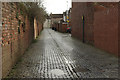
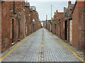
End of Belvedere Road, Darlington
Looking from Clifton Road along a cobbled alleyway past the end of Belvedere Road.
Image: © Stephen McKay
Taken: 10 Dec 2014
0.10 miles
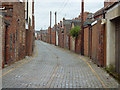
9
Back Alley
Alley between the rears of Victoria Embankment and Bedford Street
Image: © Richard Croft
Taken: 21 Sep 2011
0.11 miles
10
Back Alley
Alley between Victoria Embankment and Bedford Street
Image: © Richard Croft
Taken: 21 Sep 2011
0.12 miles