IMAGES TAKEN NEAR TO
Wordsworth Road, DARLINGTON, DL1 5BE
Introduction
This page details the photographs taken nearby to Wordsworth Road, DL1 5BE by members of the Geograph project.
The Geograph project started in 2005 with the aim of publishing, organising and preserving representative images for every square kilometre of Great Britain, Ireland and the Isle of Man.

There are currently over 7.5m images from over14,400 individuals and you can help contribute to the project by visiting https://www.geograph.org.uk
Image Map
Images are licensed for reuse under creativecommons.org/licenses/by-sa/2.0
Notes
- Clicking on the map will re-center to the selected point.
- The higher the marker number, the further away the image location is from the centre of the postcode.
Image Listing (18 Images Found)
Images are licensed for reuse under creativecommons.org/licenses/by-sa/2.0
Image
Details
Distance
1
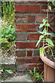
Benchmark on #132 Parkside
Ordnance Survey cut mark benchmark described on the Bench Mark Database at http://www.bench-marks.org.uk/bm78673
Image: © Roger Templeman
Taken: 9 Sep 2016
0.09 miles
2
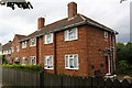
Semi-detached houses on Parkside, #132 nearest
There is an OS benchmark Image on the near corner, right hand face of #132, left of the small trellis
Image: © Roger Templeman
Taken: 9 Sep 2016
0.09 miles
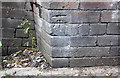
4
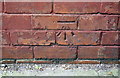
Benchmark on abutment wall of railway bridge, Parkside
Cut mark described on the Bench Mark Database at http://www.bench-marks.org.uk/bm78674
Image: © Roger Templeman
Taken: 9 Sep 2016
0.13 miles
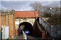
5
Railway Bridge ECM5/96, Parkside
There is an OS benchmark Image on the wall at the left hand side of the entrance to the bridge
Image: © Roger Templeman
Taken: 9 Sep 2016
0.14 miles
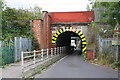
7
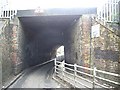
Underpass beneath East Coast Main Line
For pedestrians and width restricted vehicles only.
Image: © Stanley Howe
Taken: 4 Apr 2009
0.14 miles

9
Benchmark on Railway Bridge DSN1/1
Ordnance Survey cut mark benchmark described on the Bench Mark Database at http://www.bench-marks.org.uk/bm78675
Image: © Roger Templeman
Taken: 9 Sep 2016
0.16 miles
10
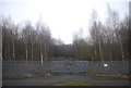
Woodland by the ECML south of Darlington
Image: © N Chadwick
Taken: 21 Feb 2011
0.17 miles