IMAGES TAKEN NEAR TO
Tanners Mews, CROOK, DL15 9UG
Introduction
This page details the photographs taken nearby to Tanners Mews, DL15 9UG by members of the Geograph project.
The Geograph project started in 2005 with the aim of publishing, organising and preserving representative images for every square kilometre of Great Britain, Ireland and the Isle of Man.

There are currently over 7.5m images from over14,400 individuals and you can help contribute to the project by visiting https://www.geograph.org.uk
Image Map
Images are licensed for reuse under creativecommons.org/licenses/by-sa/2.0
Notes
- Clicking on the map will re-center to the selected point.
- The higher the marker number, the further away the image location is from the centre of the postcode.
Image Listing (14 Images Found)
Images are licensed for reuse under creativecommons.org/licenses/by-sa/2.0
Image
Details
Distance
1
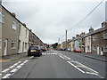
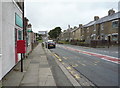
Wilson Street, Stanley Crook
Looking north west on the B6299.
Image: © JThomas
Taken: 27 Aug 2018
0.06 miles
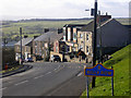
2
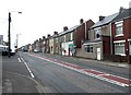
North Lane, Stanley Crook
The main B6299 road through the village.
Image: © Oliver Dixon
Taken: 17 Jul 2020
0.07 miles
3
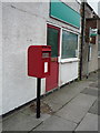
Elizabeth II postbox on North Lane, Stanley Crook
Image: © JThomas
Taken: 27 Aug 2018
0.07 miles
4
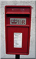
Close up, Elizabeth II postbox on North Lane, Stanley Crook
Postbox No. DL15 107.
See Image] for wider view.
Image: © JThomas
Taken: 27 Aug 2018
0.07 miles
5
North Lane (B6299), Stanley Crook
Showing position of Postbox No. DL15 107.
See Image] for postbox.
Image: © JThomas
Taken: 27 Aug 2018
0.08 miles
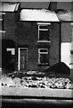
8
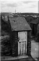
Outside WC, rear of 4/5 Railway Terrace Stanley, Crook
Outside W.C.s were commonplace before the terraced houses were modernised. In this case, the back yard and steps up to the WC or "nettie" had to be negotiated. A trip at night required a candle or a torch and a thick dressing gown and slippers in the winter (at 700 feet above sea level).
Image: © Tom Jolliffe
Taken: Unknown
0.21 miles
9
4/5 Railway Terrace, Stanley, Crook
Houses in this village were gradually modernised with grant aid after the Durham Council abandoned its "Category D" i.e. no development policy, in the 1970s.
Image: © Tom Jolliffe
Taken: Unknown
0.22 miles
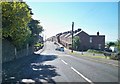
10
Billy Hill near Crook
Looking north-west down the steep hill into Billy Row
Image: © Oliver Dixon
Taken: 17 Feb 2006
0.23 miles